A Fleeting Light
Light. It is a photographer’s most fundamental consideration. Landscape photographers invest hours of research and planning, endure countless attempts at trial and error, and expend blood, sweat, and tears to chase the perfect light. It is the one physical element, more so than composition of subject, that can make or break the rendering of a quality photograph.
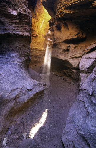
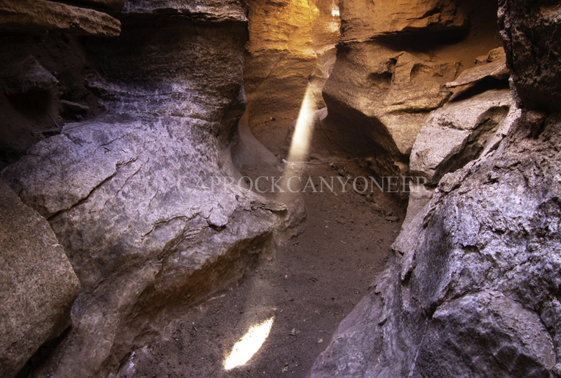
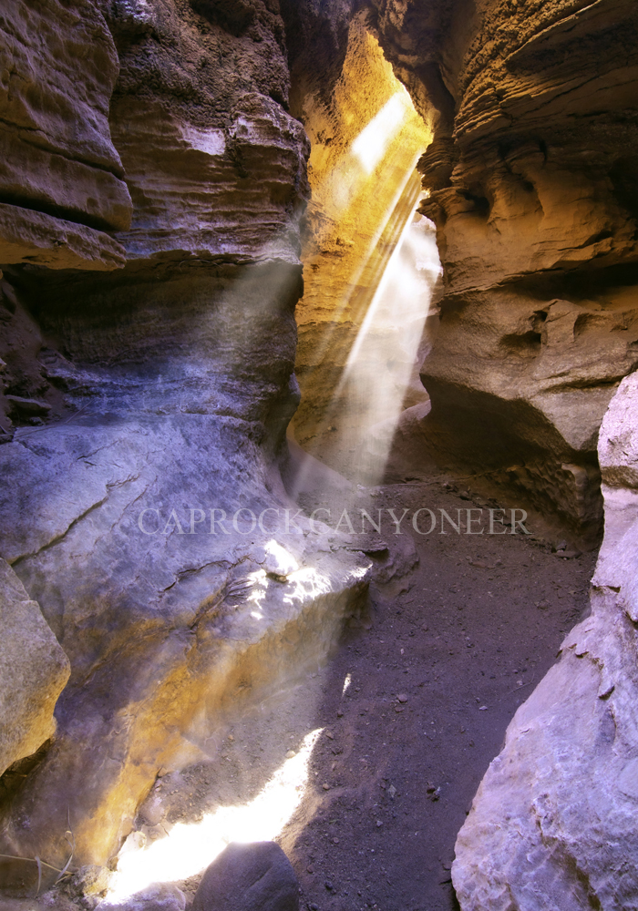
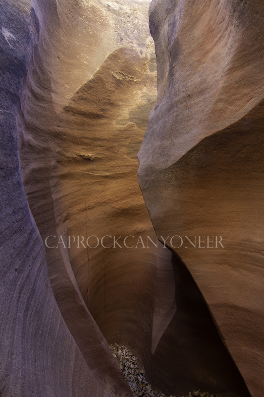
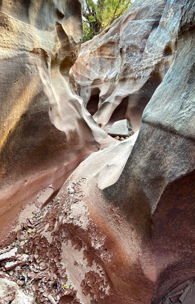
I had photographed a small Quartermaster sandstone slot canyon in Palo Duro Canyon State Park numerous times. When I stumbled onto this slot years ago, it was chalk full of black widow spiders. Hence, I called the place the Deathly Hallows. On at least one of my past visits, the canyon harbored warm reflected glows of light on the canyon walls, however, I had never witnessed the Heavenly apparitions that I recently captured there. In fact, I had rarely captured such luminatory phenomenon anywhere in the Llano Canyons. I first encountered light beams penetrating the dimly lit depths of a Llano slot on a hike to South Cita Canyon’s Slenderman. I was convinced that what I witnessed there was a geophysical novelty of time and place.
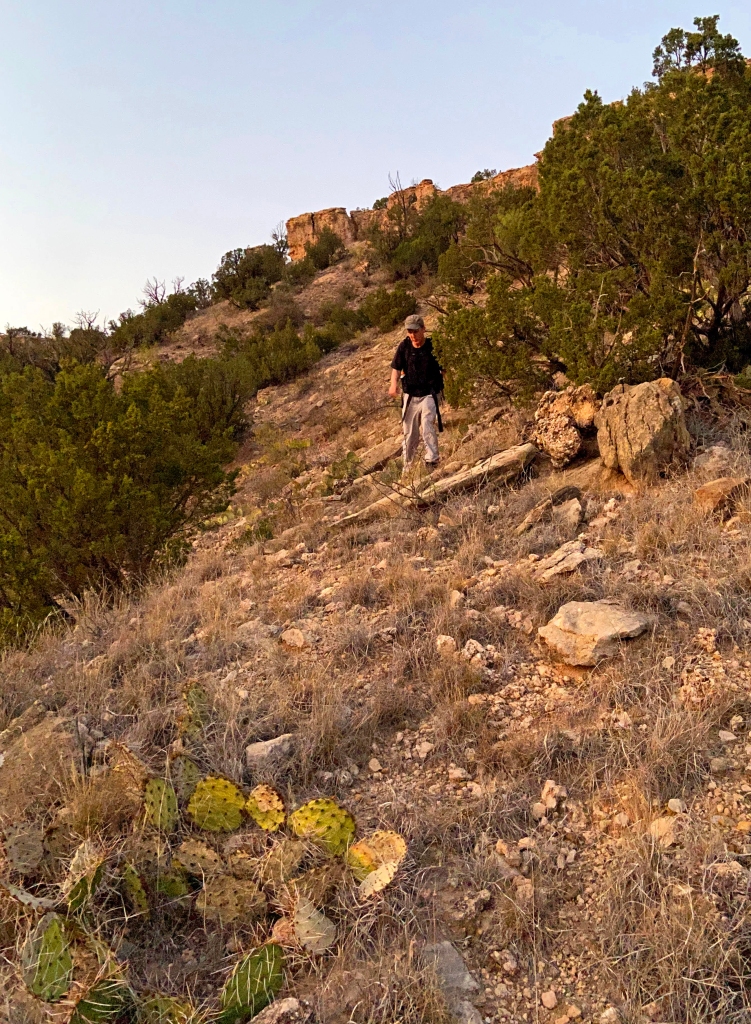
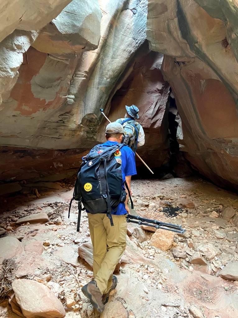
 Needless to say, I was not expecting brilliant light beams from above when I trekked out to the Deathly Hallows on this particular day in the canyon. My long-time hiking partner, Barry, had however, recently captured some beautiful images of this small geologic treasure filling with intense warm glows, so I had reason to believe I was in for a show. My initial hike out to the slot was met with an overgrown obscure backcountry trail and then a climb up a crumbling sandstone cliff, followed by a few up-and-downs over yucca and prickly pears. Before long I found myself squeezing through the tight confines of the Deathly Hallows.
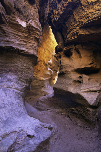
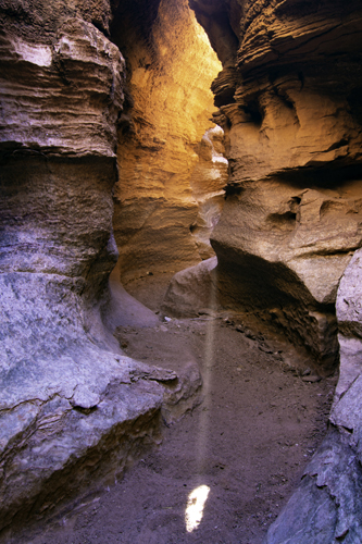
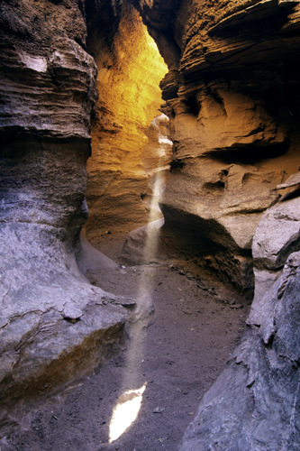
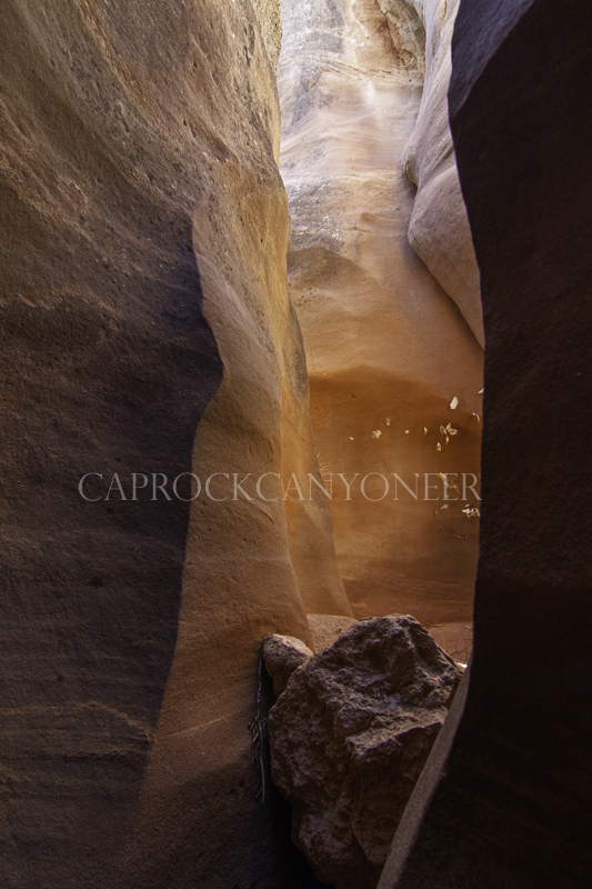
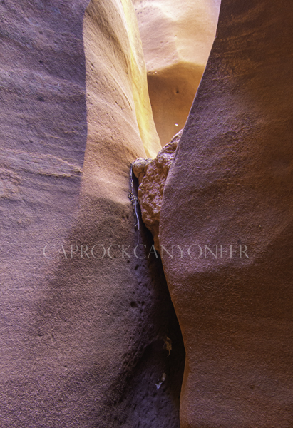
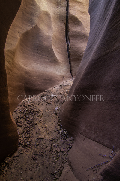
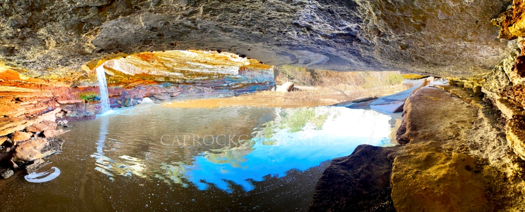
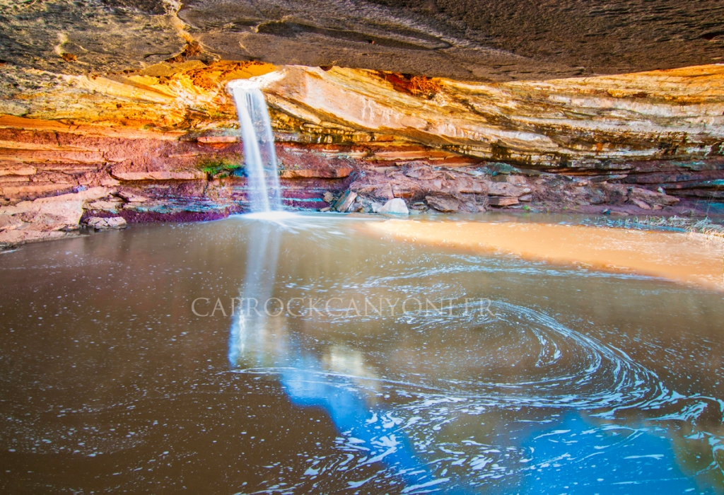
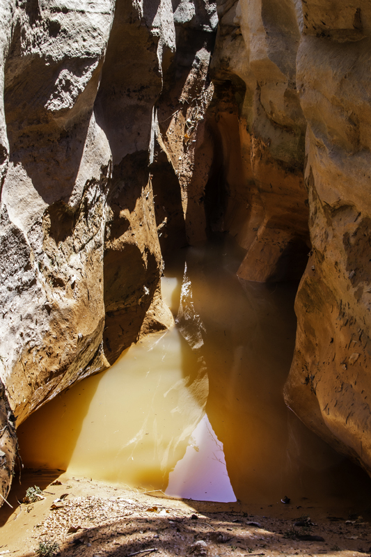
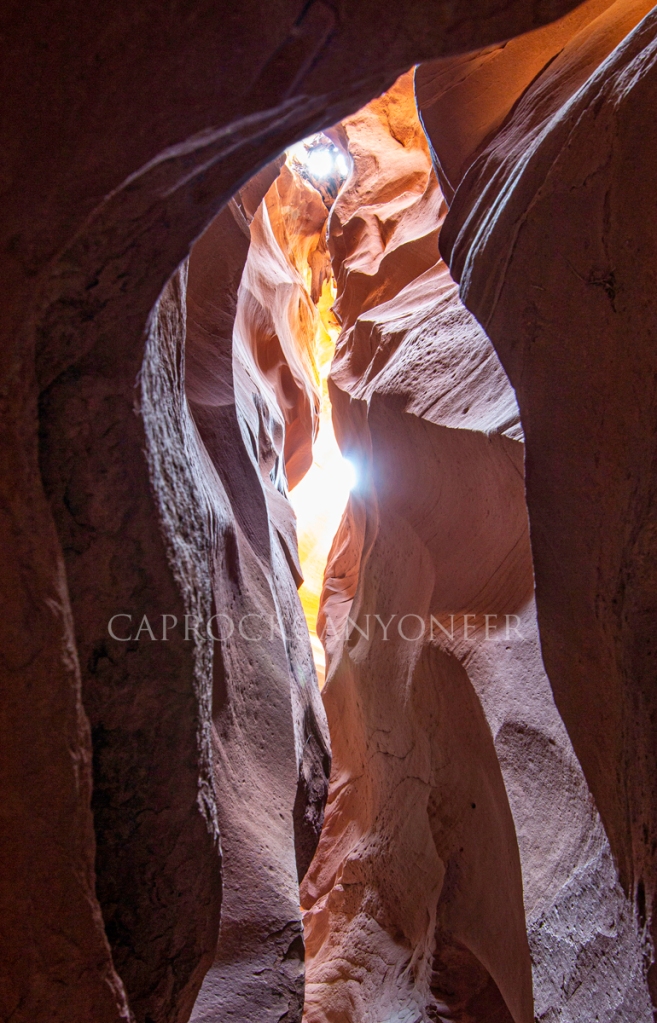
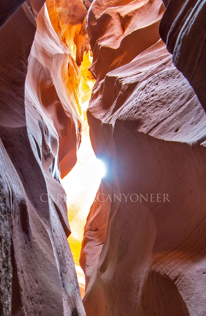
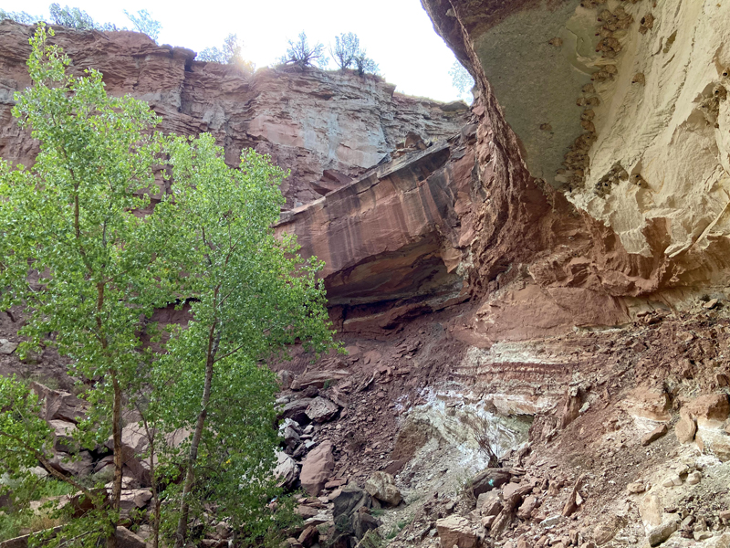
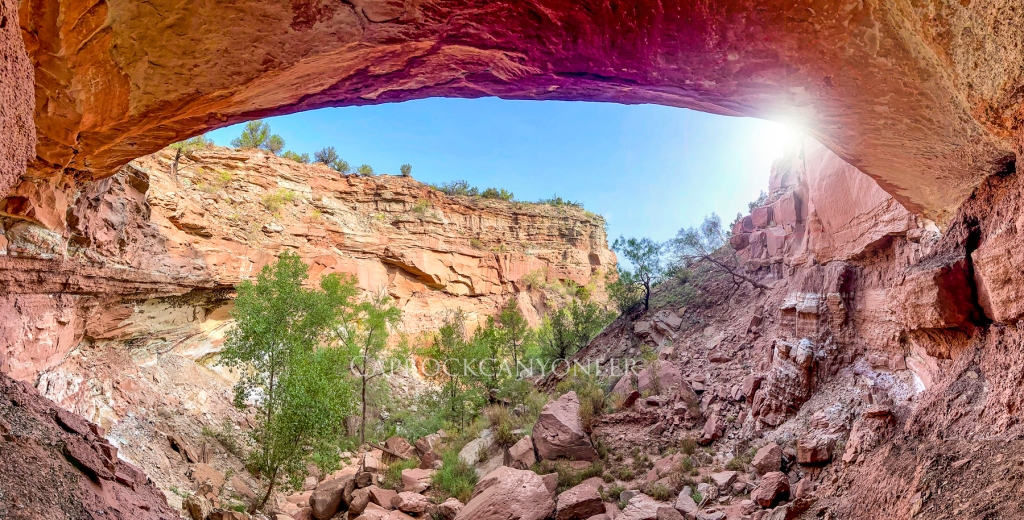
 Being a Quartermaster sandstone slot, this is not the most striated or structured slot, but it does feature several nice curves and even a bell-shaped wall. Not long after I arrived, the live-view LCD on my Canon DSLR started to show the warm glow that I was anticipating, and it was glorious. One feature of this slot that I had pretty much not noticed before, is that it contains a short section that is effectively a tunnel. A portion of the shallow canyon’s rim folds over to form an arch, or bridge. As I focused on capturing the best photographs I possibly could of the intense earth-toned glows occurring on the curved walls of the tiny slot canyon, I began to notice a bright spot in the sand at my feet, right under my tripod. The first thought that came to my mind when I realized what was happening was, “no way!”.
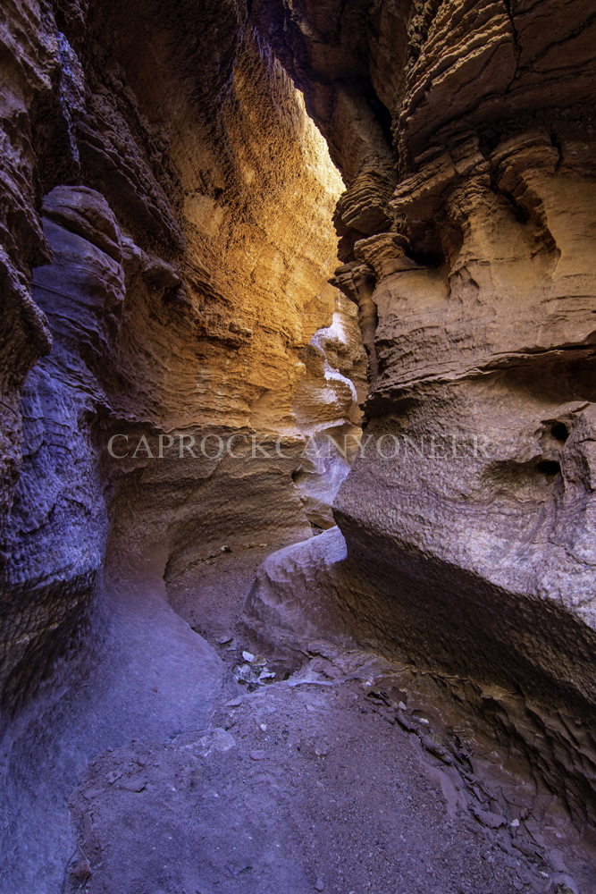
There are times in nature when it is difficult to comprehend the beauty that is transpiring before us. This was one of those moments. During the next fifteen minutes, my attention was solely focused on trying to document what I was witnessing. Bright sunshine filtered into a tiny opening in the natural bridge above, and illuminated a shaft of light that shown on the sandy canyon floor right in front of the canyon walls that were intensely glowing with indirect light. Toggle through the slide show below (four images) to see the evolution of this apparition, an anomalous display of nature hidden deep in the bowels of the Texas Panhandle.
I am the light of the world. Whoever follows me will never walk in darkness, but will have the light of life.
John 8:12
I am the way, the truth, and the life. No one comes to the Father except through me.
John 14:6
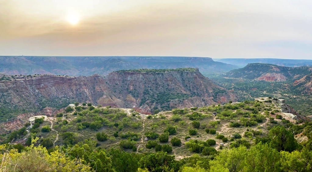
As quickly as the light entered and traversed the narrow passage, it completely filled and saturated the slot canyon, and the show was over. As I emerged from the tight confines of the slot, the feeling of having witnessed something special was overwhelming. I found myself impatiently downloading images straight to my phone enroute to the parked car, and immediately texting them to Barry as soon as I could secure a cellular signal. On the hike back, I forced myself to take the time to simply pause and take in the view of the larger grandeur of Palo Duro Canyon.
Of course, my account prompted Barry to revisit the Deathly Hallows just a couple of days later. He captured a similar light beam apparition, but it was clear that just a matter of 48 hours made a difference in the angle, intensity, and time of the light pouring into this little hidden canyon. These glorious beams from Heaven appear to be exceedingly fleeting. Catch them if you can, but I am thankful to have served witness to nature’s lights in a tiny and dusty little trench He carved through the badlands of west Texas. Through what fleeting instant of natural beauty will He reveal Himself to you? You better get outside and explore to find out!
A Chuck Wagon, Slot Canyon, and Enchiladas
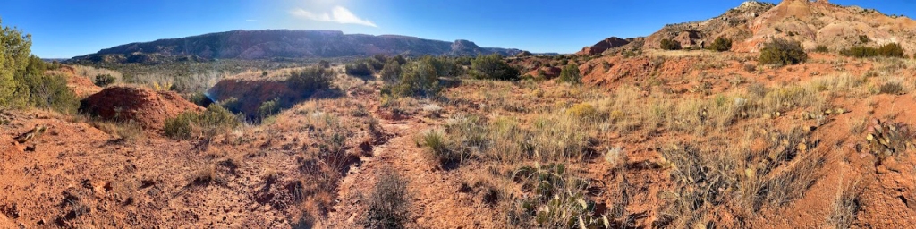
As I have said before, when it comes to exploring the canyons of the Llano Estacado, patience and persistence pay off. Way back when my family resided in the Hub City of the Llano, a decade ago, the resolution of Google Earth first became sufficient to identify a slot canyon on the rim of lower Palo Duro. Not long prior to that, the state park had undergone an expansion into the area with the promise of increased public access. Therefore, I never gave up hope of someday exploring what looked from space to be a sinuous narrow slot. Alas, today, the lower portions of Palo Duro Canyon State Park remain tied up in access-denying ranch leases. Through the years, it has become obvious that any hope of reaching this particular feature would have to be dependent upon access granted from private land owners.
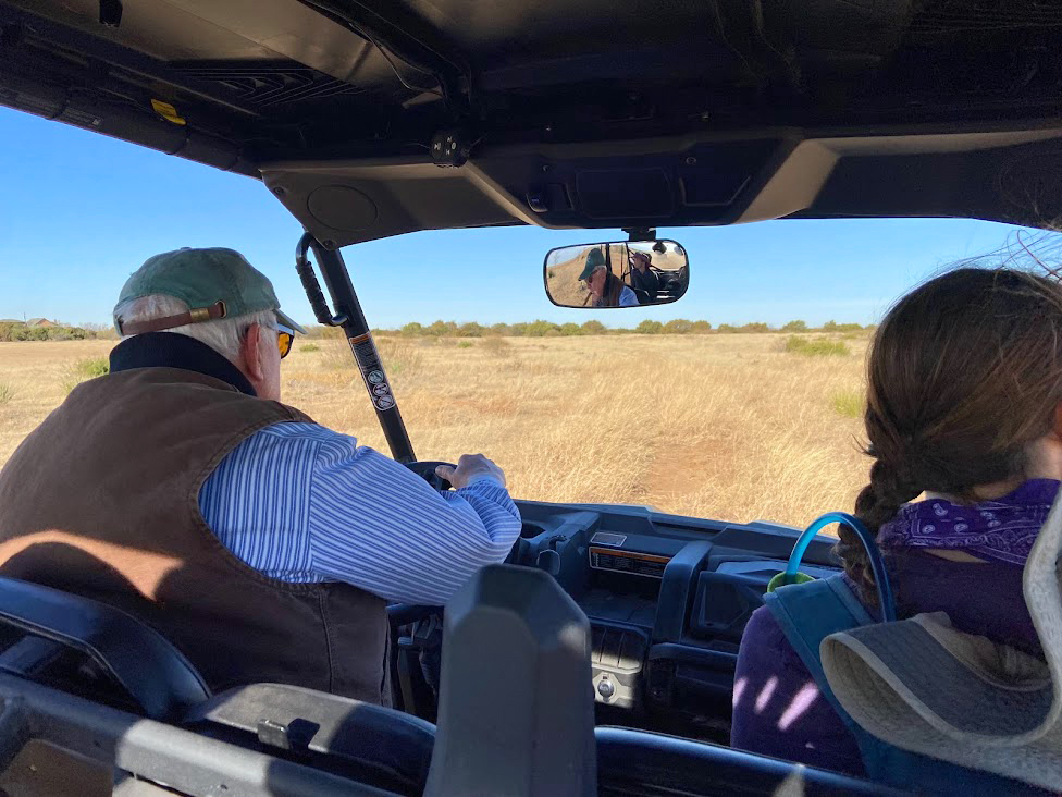
In the interim, a growing number of people have taken an interest in exploring the Llano Canyons. One such enthusiast is Darla. I hiked with Darla (and others) on an adventure in South Cita Canyon the previous year. Darla and her family, non-Llano natives, have grown to fully appreciate the untamed wilderness found in the canyons of the Caprock escarpment, and have developed their own network of contacts in the region in pursuit of scenic places and history. Darla, her husband, Matthew, and their daughter, Madeline, were able to arrange a visit with a very gracious landowner near the long coveted slot canyon. I was fortunate enough to be invited!
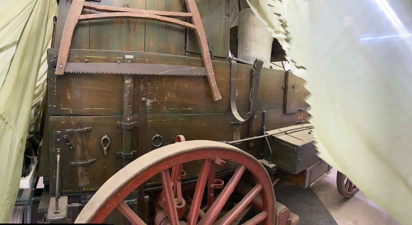
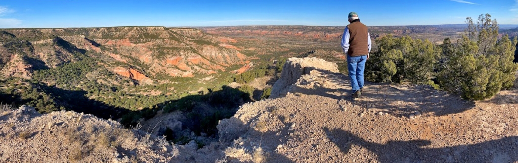
When we arrived at the property, our host gave us a tour, which included his workshop. My jaw dropped to the floor when he raised a tarp and said, “over here is the chuck wagon my grandad came here in back in the 1880s”. It was astonishing to see the preserved piece of family and Panhandle history. Later, he ushered us to a wonderful point on the rim, where the view is so beautiful that a number of weddings have been officiated there throughout the years.
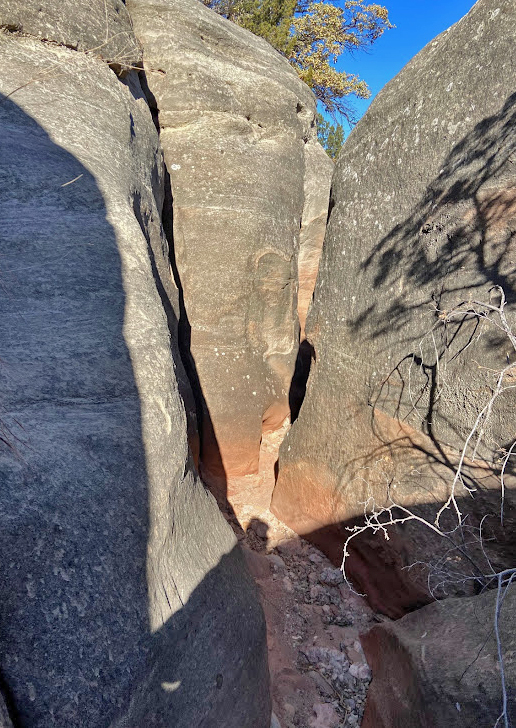
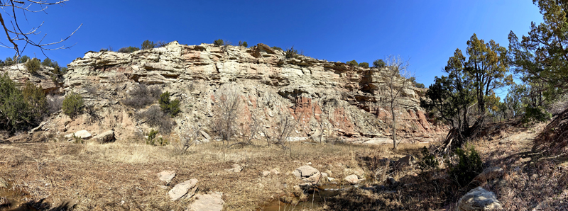
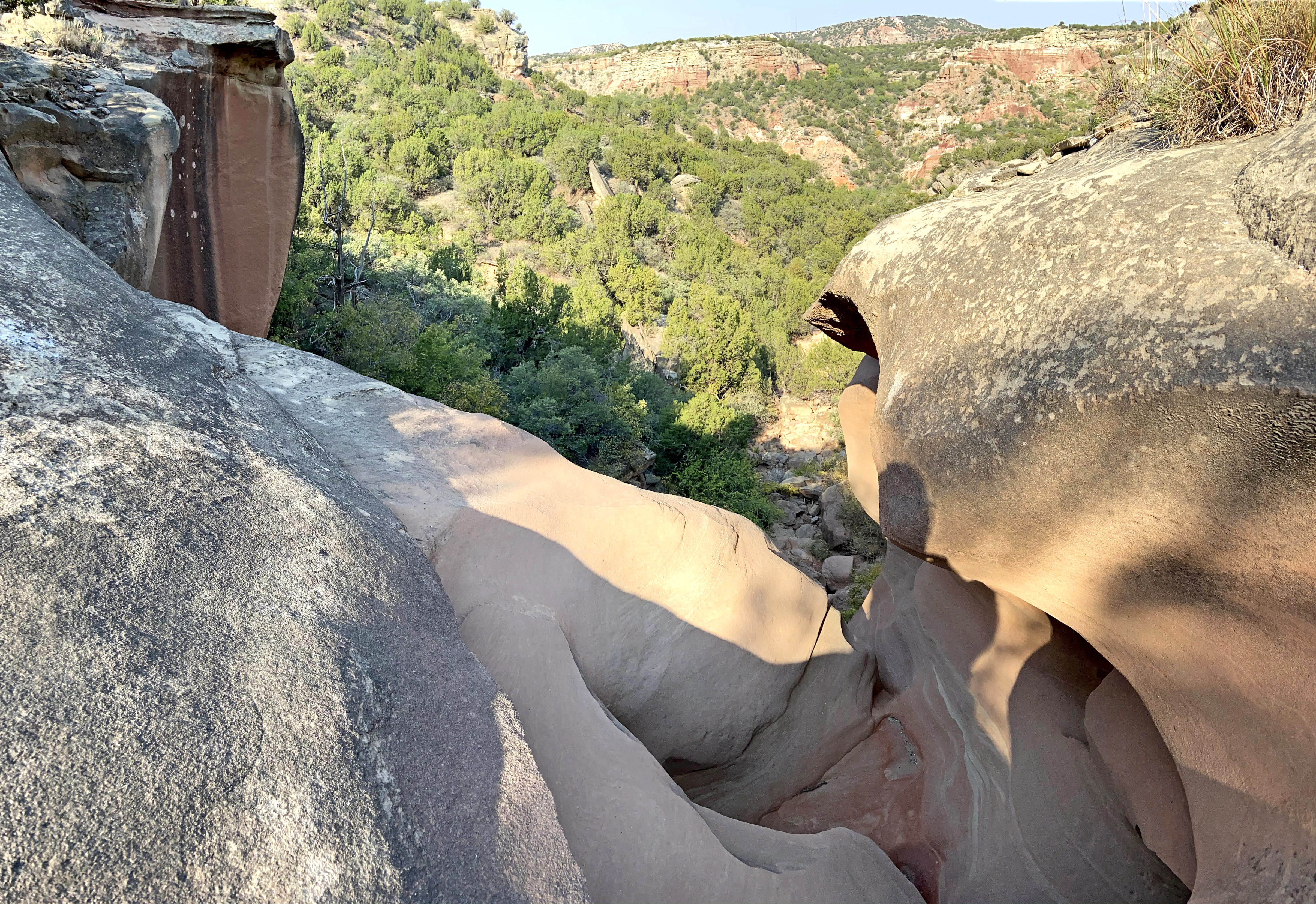
We were able to descend from the scenic point straight into the side canyon that harbors the slot canyon. The outcropping of Trujillo sandstone that is found exposed on the “middle rim” of the canyon was cut into a sharp and narrow trench that snaked its way to a dramatic chute. The slot was “Y”-shaped and only about five to six feet deep for most of its length, but then descended a couple of steep ramps in the final thirty feet of course before the dramatic chute that emptied to the lower canyon below. Within this final thirty feet, the slot “s”-curved back onto itself two times, creating miniature sections that were shining with a soft warm glow of, pink, orange, and earth-tone purples. I spent quite some time in the lower portions of the slot photographing the warm glows on striated canyon walls. On one such wall, a number of fallen autumn leaves were caught suspended in a spider’s web, creating a scene custom made for the season. The slot certainly lived up to my hopes for it to be photogenic after trying for so long to get to it, and I was thrilled to finally photograph it.
Matthew taking in the view atop the mouth of the slot
As everyone in our small party took turns snapping photos within the tight confines of the slot, Matthew and I took in the view from above looking out over lower Palo Duro Canyon. As we did, we discussed the giant cedar tree below, and pondered its age. As I have referenced before, there are frequently abnormally large trees sheltered in the head of box canyons near dramatic falls and slots. I affectionately call these “alpha trees”. That’s just my non-technical term for trees that are well positioned within the canyon to have a competitive advantage within the protected confines of sandstone. It stands to reason that these trees also benefit from the copious water that flows through, carves, and pools below these dramatic geological features as well. We also chatted about mutual acquaintances and fishing. It turns out Matthew is an avid fisherman, and less of a hiker, but he took on the challenge of this day’s offtrail adventure like a pro.
As we ascended back up to the rim, we contemplated the history of this area, the lower portion of Palo Duro Canyon. While we did not descend there today, the old Indian trail used to access the historic campground and battlefield was not far away. Hence, the handful of hikers that had managed to access this photogenic little slot before had coined it “Comanche Slot”. Thanks to the access granted by our gracious landowner host, the hike out and back was short, but very steep and treacherous in spots. We gained approximately 300 feet elevation in a horizontal distance of less than a quarter mile. While that may not sound too bad on an established trail, it’s another story when you are bushwhacking and scrambling. On our final crawl up the loose and crumbling Ogallala formation near the rim and the relief of the Plains above, Matthew, commented to his offtrail veteran family members, “If the goal of this hike was to make a point about how many enchiladas I eat, message received!”. I instantly stopped and half- jokingly warned them that the comment was an offtrail classic, and that it would be repeated on my blog, and that’s how we covered chuck wagons, slot canyons, and enchiladas, all in one epic adventure.
As we achieved the rim and looked back out over lower Palo Duro Canyon, we could see the new Merus Adventure park in one direction, and the restricted and inaccessible wilderness that is the vast majority of state owned land in Palo Duro Canyon State Park in the other. Earlier I stated that patience pays when it comes to accessing the west Texas canyons. Conversely, acts of impatience result in restrictive actions, the likes of which we have seen around Palo Duro Canyon during the past year. I too have suffered from impatience, but I hope that other west Texas nature enthusiasts can see that access to these canyons is gradually increasing. Slowly but surely, opportunities for more and more people to enjoy the Llano wilderness are opening. This hike is a result of such perseverance, the kind of which is needed to explore the canyons of west Texas. Most people will eventually gain opportunities through the increasing number of privately owned sanctuaries and parks like Pole Canyon Ranch, Merus, and the Red River Refuge at River Falls. The vision to open these landscapes is being gradually realized by private entities, not our tax-funded public agencies entrusted with protecting these lands and administration of our parks. There is reason for optimism, even if the source of that optimism is unexpected.
Homage to the Chief
The geologic wonders of the Llano Estacado, such as slot canyons, arches, and waterfalls, are all mystic enough. Yet, it is quite possible that the most mysterious features of the Panhandle’s natural history are it’s lithic ones. Rock art sites are probably the most overlooked and forgotten. Of such, probably none are as forgotten as this one.
Most modern Texas Panhandles residents have no clue that such sites even exist on the Texas Plains. Those that do know about them are frequently their most staunch protectors, usually being private land owners who literally shelter them with secrecy and locked gates. The extreme climate of the Llano Estacado with its dramatic fluctuations of wet and dry make fragile rock art vulnerable to erosion and destruction from landslides and other forces of nature. Many more fall victim to vandalism. Not all rock art in the Llano canyons is pre-historic. Many sites found today are likely frontier cowboy art.
Not far off of the well beaten path that once bore the tracks of the Sad Monkey Railroad sits a rock art site that was likely seen by thousands of tourists as a point of interest highlighted by eager-to-impress rail guides. For many, the rock art site likely was a conveniently placed embodiment of the canyon’s place in Native American history. Possibly too convenient.
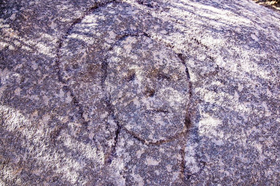
The origin of the Indian Chief glyph is debatable. Its presence in the canyon was of interest to an archeological dissertation at Texas Tech University in the 1970s (Upshaw 1972, figures shown below). The site was surveyed along with a number of other pre-historic sites in the area, but the artist was not determined to be definitively Indian. It could be the work of CCC workers who did extensive projects and make many marks on boulders in the immediate vicinity. As previously inferred, a nicely placed forgery made specially for the eyes of visitors who purchased a ride on the Sad Monkey is also possible.
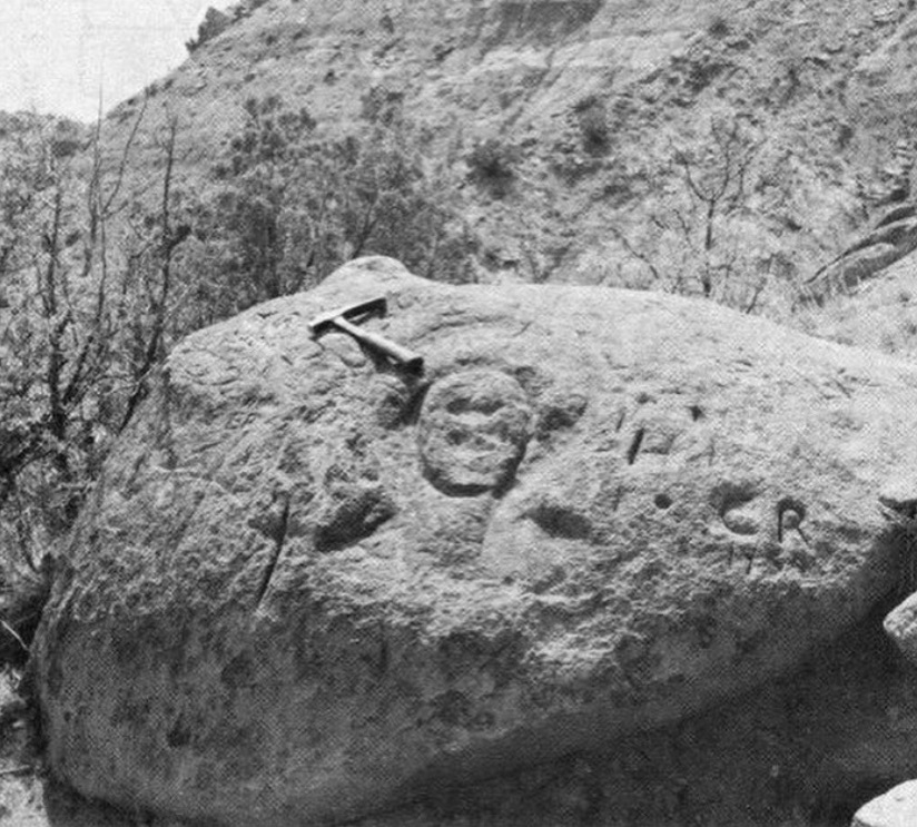
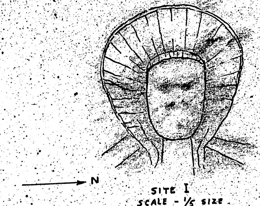
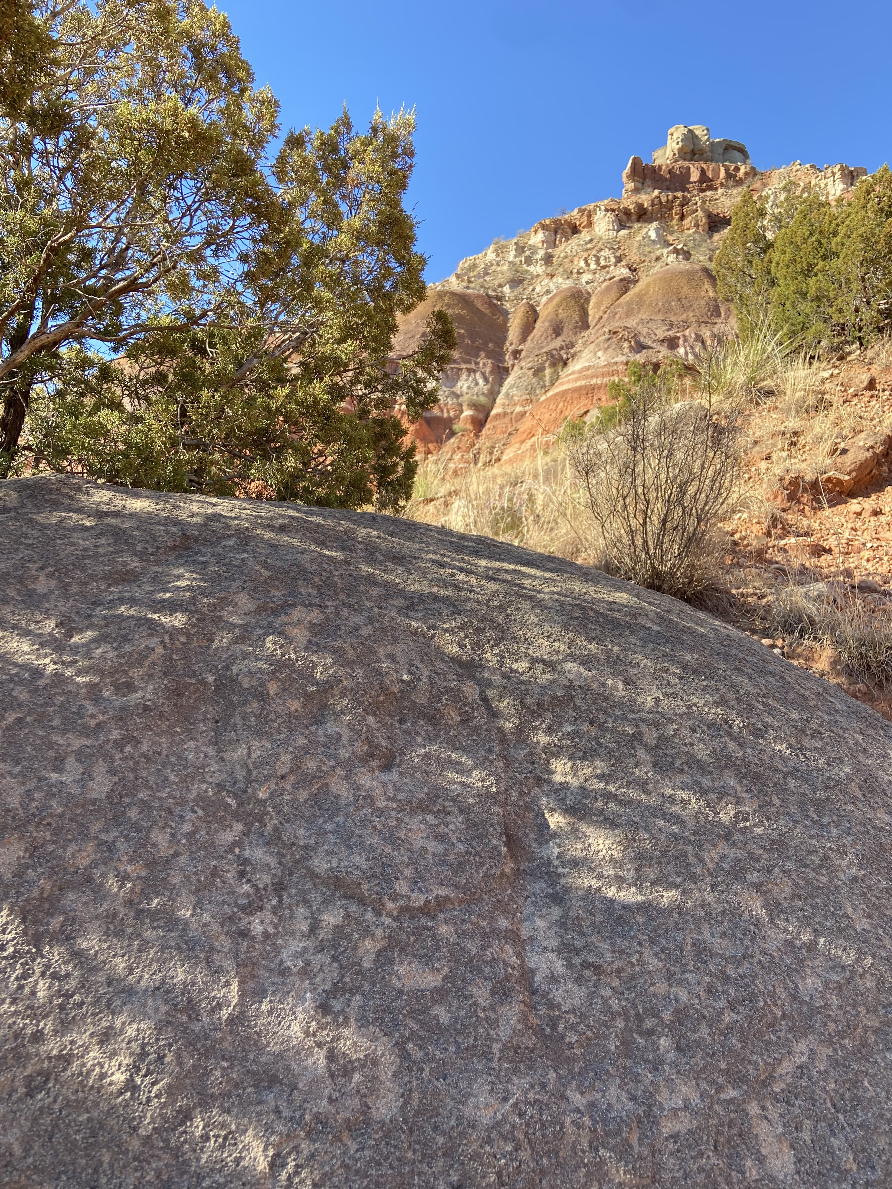
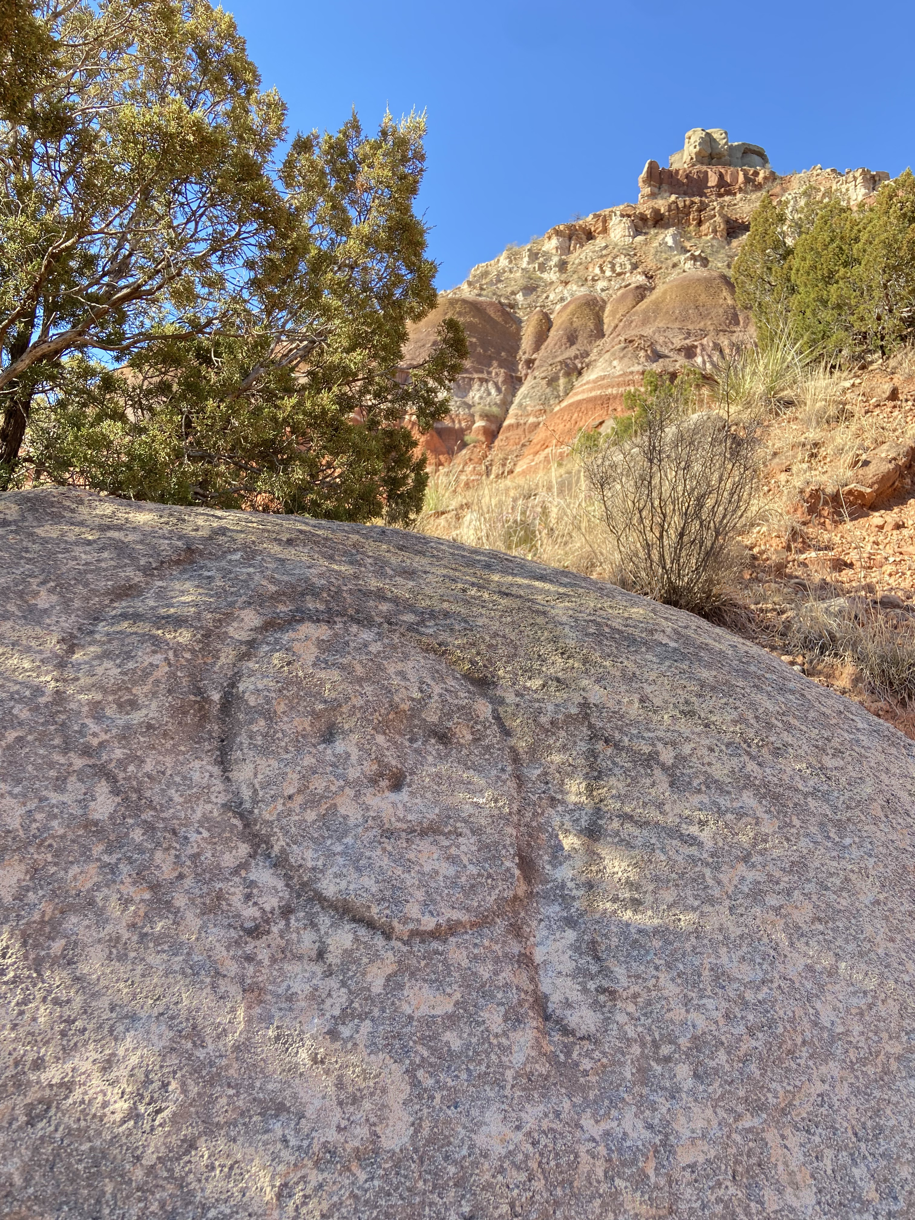
One thing is certain, the etching has not fared well over the past forty years. In fact, I would name the depicted Indian leader, Chief Crazy Faded! In my mind, this raises questions about the site’s authenticity as a pre-historic Native American site. If it has weathered so much in the last forty years, how could it have survived for centuries? Slide the image bar on the image below to see the visible degradation of the site versus my best effort to carefully and digitally “burn” a highlighted outline of the remnant figure in imaging post processing.
Regardless of the artist’s identity, the Indian Chief petroglyph should prompt us to consider a few important facts about rock art on the Llano Estacado and in its Caprock canyons. While landowners fortunate enough to have these historically important places on their land have a tendency to guard their presence with silence and secrecy, it is vital to recognize that time itself is destructive. Responsible documentation by archeologists and historically-inclined photographers should be allowed before these sites vanish forever. Secondly, while we cherish records in stone left by past generations, modern vandalism and graffiti have no place in natural places. With today’s technology, there is no acceptable reason to leave your physical mark on the natural world, and those that do so should be pursued according to the laws that protect such places.
While ‘Chief Crazy Faded’ (my sarcastic name for this particular site) may or may not be legit, even he who was the subject of exhibit for paid tours and seen by thousands has not just faded from mere physical existence but also in the memory of many who grew up frequenting our great state park. A worse fate of obscurity may await many more historically sensitive sites along the Llano’s edge as their existence is not just forgotten, but never acknowledged, their stories never understood, and their lessons never learned. There is so much history hidden deep within the folds of Triassic sandstones of the Texas Panhandle, some of it is not only hidden, it is purposefully concealed. While preservation has to be the priority, for what reason if not to inform modern and future generations of those that inhabited these canyons before us? Before we transformed the plains above, these canyons were more than pure recreational lands, they were a way of life, and the messages from that way of life should be recorded and heard today.
The Falls of South Cita
Many of the Llano Canyons’ most special places are rarely seen. They are behind pad locks and barbed wire. After a decade of documenting the hidden beauty of the Texas Panhandle canyonlands, there are still a few such places left unseen. Some of these locales, in my mind, render this meager blog incomplete in their absence from the pages of adventure stories and photographs below. Until now, most of the beautiful waterfalls in South Cita Canyon were such places.

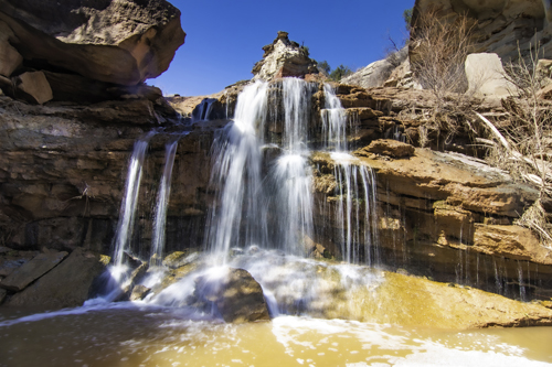
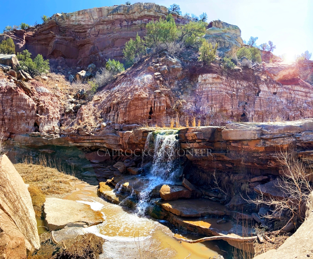
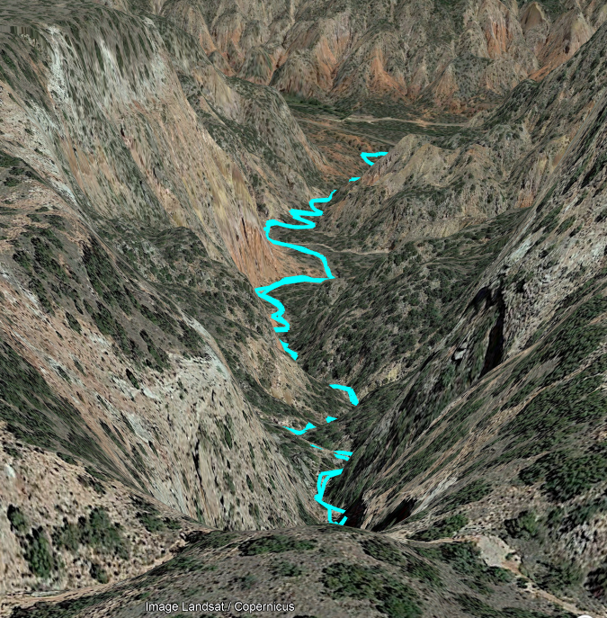
South Cita Creek is a 7-mile long tributary of the Palo Duro Canyon system. In the autumn of 2013, my oldest daughter and I shared a memorable day hiking Ceta Canyon, a church camp that occupies upper South Cita. On that hike we explored and photographed a waterfall in the glorious backdrop of a bright blue cobalt sky and yellow cottonwoods. The waterfall we visited that day in November 2013 is called First Falls, although most Panhandle residents simply know it as Ceta Falls. Many camp goers have fond spiritual memories of this legendary Caprock gem. In fact, Heaven only knows how many young souls have been impressed by its cool flowing waters- literally! Unbeknownst to most campers, this locally popularized landmark is nestled in the upper portions of South Cita Canyon, and is only the first of five waterfalls that few even know exists. When my family and I left Amarillo in 2015, I had all but given up on ever seeing the lower falls of South Cita Canyon. Patience, however, is a virtue when your passions include accessing private land in Texas! As luck, persistence, and time would have it, doors (or I should say, gates?) eventually opened.
We began the day from a point on the rim overlooking the valley of South Cita Creek. From there, we descended one of the many old abandoned and disrepaired ranch roads that can still be found along the canyon’s edge on private ranches. It was along these roads from which cedar posts harvested in the canyon were transported to the Plains above for fencing. Bary, (Nerdy Native) led the way along a relatively gentle one-mile route that guided us from the rim to a broad v-shaped outcropping of Trujillo sandstone where the mainstem of South Cita Creek sharply drops in what has historically been called “Third Falls”. For past generations, it is rumored this waterfall and the particularly deep pool at its base surrounded by a natural sandstone ledge was a popular swimming hole. Long since forgotten by today’s modern west Texans, I have wondered if this is the famed “blue hole” referenced in the writings of Dr. Flores near the junction of the Cita Creeks. For sure that it is, I am not, but it’s beauty matches most of those descriptions, even if the geographic location seems off just a bit.
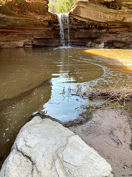
Eager to capture a particular view, I quickly scrambled down the cliffs just downstream of the falls. My primary objective on this hike was to photograph the scene from below the v-shaped sandstone shelf surrounding Third Falls. Bary, having previously hiked (with permission) to this location, had captured a beautiful image from beneath the falls, and I could not wait to attempt my rendition. As one arrives at the base of the pool below Third Falls, it is a short crawl on all fours to sneak under the expansive sandstone ceiling guarding the hidden water feature. Once below, the shelter expands to nearly five feet in height, just enough space to comfortably relax and take in the drowning but peaceful sound of falling water which echoes off of the sandstone (YouTube video clip). Upon our arrival, direct sunlight was bisecting the pool, but a stunning reflected light cast a brilliant warm glow around the glistening falls. It was truly a beautiful sight, and the panoramic images I captured here will make a brilliant companion piece for the Red Canyon images taken late last year.
From Third Falls we continued downstream weaving from one side of the stream to the other, basically following the path of least resistance on the driest ground possible. The spring season had been very active weather-wise, with severe storms and tornadoes followed by a blizzard the week prior. Vegetation along the streambed showed evidence of a recent flood, and even a few large trees were downed.
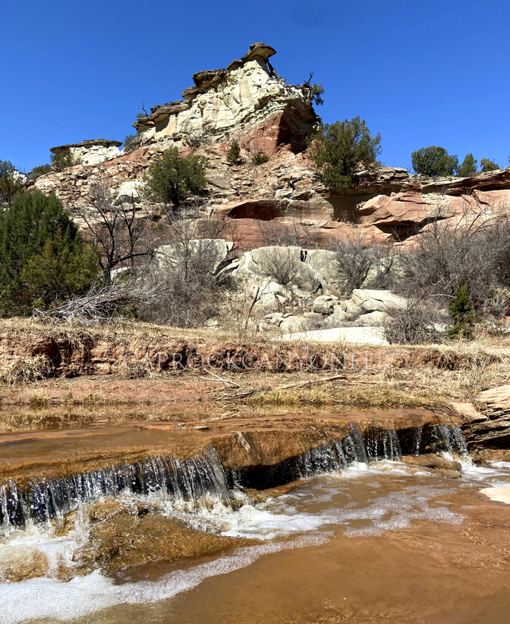
The sandstone canyon walls between Third Falls and our next point of interest, Fourth Falls, were impressive to say the least. Photos do not do this section of the canyon justice. Sheer vertical cliffs nearly a hundred feet tall lined the creek, some cut from concave-shaped Trujillo outcroppings. Earlier I mentioned the writings of Dr. Dan Flores. He once wrote about places that likely had spiritual significance to the Plains Indians. Places where nature seems to speak to you. I had never experienced that in the way I did on this hike. At one of the convolutedly contorted sandstone walls undercut by a cascading trickle of South Cita Creek, it was almost like you could hear voices echoing off of the curving stone walls – voices from the past? It was just running water echoing off of the rocks, but I repositioned myself several times on the opposing side of the creek to hear the effect fade in and out, just to make sure I wasn’t imaging it. All while my hiking partners, Bary and Dusty explored from other perspectives along the creek. I didn’t dare tell them of my experience, because it seems crazy, right?
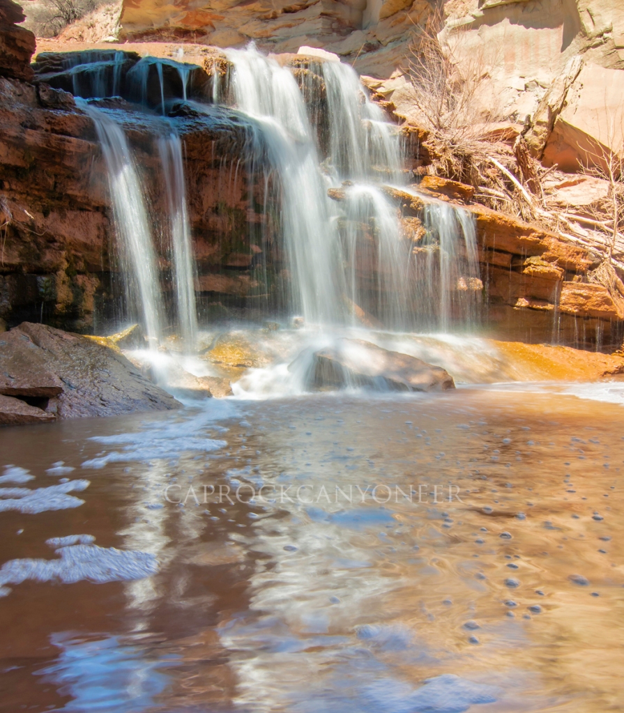
The dramatic landscape made classic west Texas canyonscapes, with massive ship-like sandstone formations rising high above meandering streams of cold, clear, cascading water. We eventually hit a place where the ground stepped down again to form the Fourth Falls of South Cita Canyon. While this is the smaller of the lower South Cita waterfalls, it is particularly picturesque (YouTube Video).
As we progressed further down the remarkable waterfall-filled canyon, a pair of golden eagles circled high overhead. Along a narrow stretch of the creek between Third and Fourth Falls, near the special place where the rocks talked to me, one of the majestic raptors walked down the creek bed before taking flight. As it did, its wing span was massive, appearing to reach across the entire breadth of the creek, which I would estimate the width of the water course to approach 8 feet in that spot! I am sure some of the apparent size could be due to perspective, but it was probably the largest bird I’ve ever seen, much less in west Texas.
As we descended below Fifth Falls, the character of the canyon abruptly changed. Above, the canyon was riddled with Trujillo outcroppings with almost mystical shapes, including apparent cones and pyramids, but below this lower falls, the canyon was dominated by the Tecovas formation. Although we didn’t progress any further downstream, the creek bed appeared to be comprised of huge Trujillo boulders that had tumbled down throughout the millennia, and I could even see the top half of a pure Tecovas dome, or slide. This was, however, a place I had always wanted to see. The State Photographer of Texas, Wyman Meinzer, once photographed this location for his book, Canyons of the Texas High Plains. He captured it under near perfect conditions in autumn, but my view on this bright sunny spring day included harsh afternoon sun. Still, the scene was much more dramatic than I envisioned, with a castle of sandstone filling the backdrop (YouTube video clip).
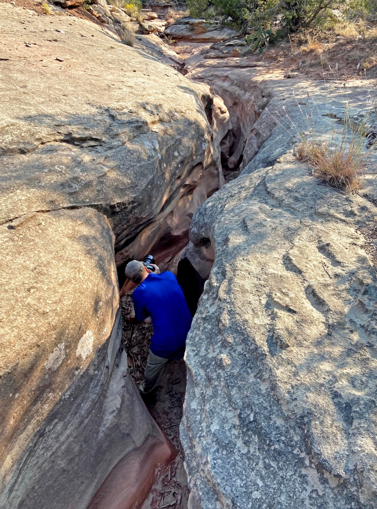
Of course, few of my hikes in the canyons of the Llano Estacado are complete without detouring to find a slot canyon. This one was no exception. On our exit route back to the rim, Bary navigated us up through a narrow side canyon which contained an uniquely green tinged and highly weathered sandstone. The canyon eventually contracted into a slot. Our passage was restricted by deep water holes, but the scene was quite photogenic.
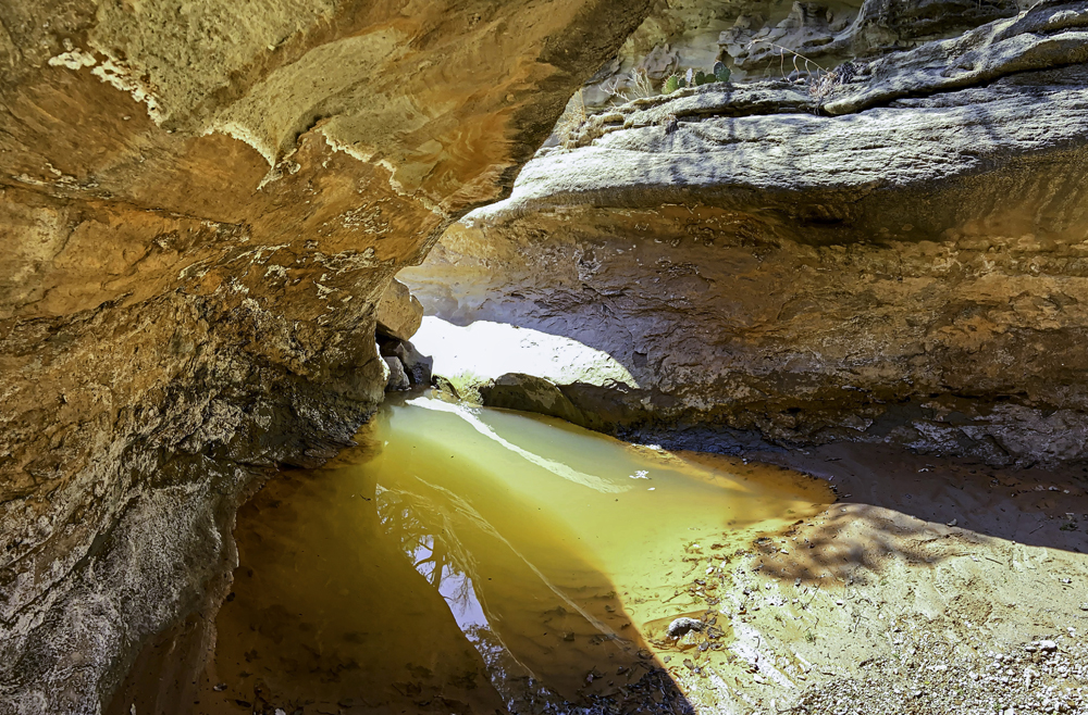
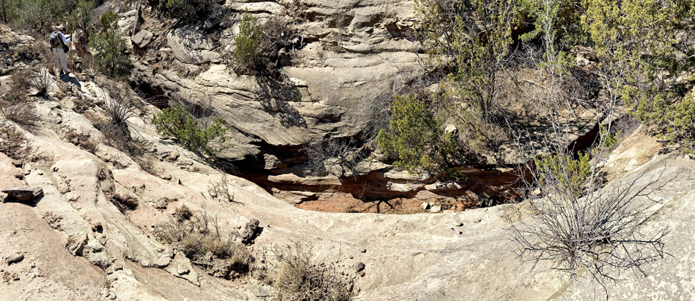
To continue our advance, we had to obtain high ground and scramble along the rim of the slot. The tightest and deepest sections of the canyon were water-filled, but I managed to stem my way over water and mud to find a suitable place to photograph the narrowest confines of the slot. This section was about six feet deep and about one to two feet wide. Once I emerged from the slot dry, well- mostly, the return ascent to the parked vehicles on the south rim of South Cita Canyon was uneventful, except for when we apparently startled a skunk along the old ranch road.
Many thanks to Bary and Dusty for inviting me to see this largely forgotten portion of west Texas’ canyon country. It has been a bucket list hike for me every since seeing the photo of Fifth Falls in Wyman’s book a decade ago. I know I have blogged about this many times, but patience and persistence really are the keys to obtaining greater access to the true natural wonders that remain largely unknown along the Caprock Escarpment.
Outdoor enthusiasts and west Texas naturalists that are interested in respectively enjoying these places and advocating for responsible access and conservation have encountered growing frustration and setbacks surrounding our few public lands in recent months. I put faith in the free market, and yes, there is a growing market for outdoor adventure in west Texas beyond big game hunting. Hopefully this blog, and other online resources, have sufficiently raised awareness that there is a whole other side to the ‘boring’ plains landscape of west Texas. Natural wonders that once defined the historic old west Panhandle culture and history were once considered worthy of placement in our coveted national park system, but have since been forgotten behind the barbed wire of private ownership. Meanwhile, administrators of our public lands tightened restrictions due to COVID-19, but also have been quietly protecting leases of those lands for profit by private agribusinesses. Attention Texas taxpayers! You have invested with your tax dollars in (and you think you have) a 26,000+/- acre public park in Palo Duro Canyon. Thanks to restrictions enforced by park law enforcement and privately employed ranch hands, you have access to less than half of that! I have faith, however, that some land owners will recognize the opportunity to diversify, and perhaps as we emerge from the pandemic, they will start looking for ways to expand their operations and income to include nature-based tourism. There are models for this now along the Caprock, including Pole Canyon Ranch, and the soon-to-open Merus venture in lower Palo Duro Canyon. In fact, perhaps someday, it will be possible for adventure-seekers to obtain permits and/or guides for amazing hikes such as this legendary stretch of waterfalls in South Cita Canyon. Doesn’t that sound more like the American way to celebrate our natural wildernesses versus the current reality in west Texas, where bureaucratic agencies entrusted with stewardship of taxpayer owned resources impose public restrictions for the mutual monetary benefit and profit of apparent tax-dodging ranching empires? My bet is that the promise of profits will gradually open gates and access to more of the long-held natural and historical wonders of the Llano Canyons. There is reason for optimism, but not all of the region’s landowners will be motivated to open for business. Some of them prefer to invest in keeping you off of the land your tax dollars have already bought and paid for!
‘Christmas Star’ from the Canyons
The shortest day of what has seemingly been the longest year was marked by a Heavenly celestial event. The December 21, 2020, ‘Christmas Star’ was the closest conjunction between the planets Saturn and Jupiter seen in approximately 800 years. It was the perfect scene to witness from the Llano canyons!
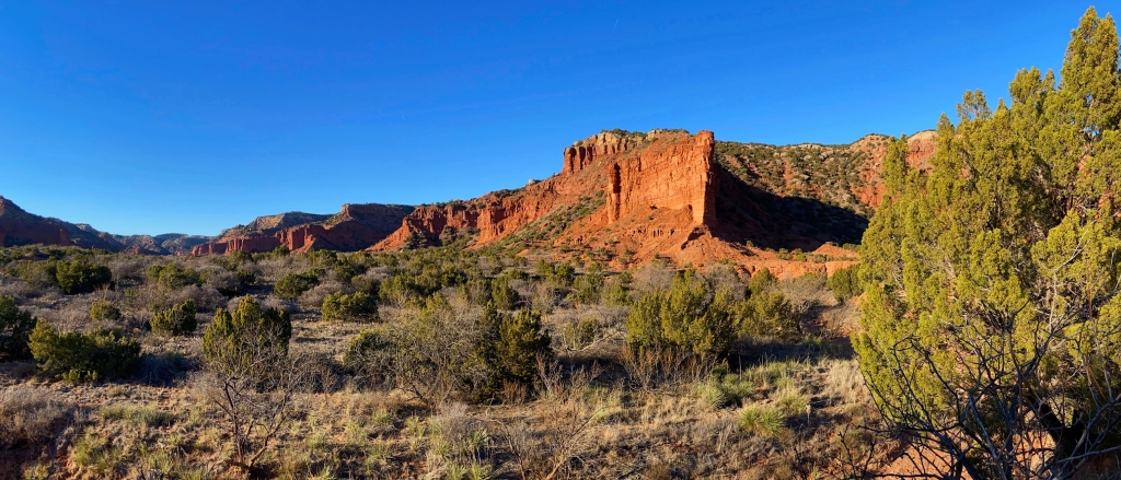
The annual state-sponsored youth draw hunt was underway in Palo Duro Canyon State Park, which always renders the best portions of the canyon closed to the public- during the Holiday Season none-the-less! So, the best option to photograph the conjunction from a dramatic west Texas canyon landscape was Caprock Canyons State Park. As I made the drive from Oklahoma into the Texas Panhandle, the familiar silhouette of the Llano’s Caprock Escarpment, or “Palisades (stacked) Plains” graced the western horizon like a distant rising tide. I never tire of the scene when it emerges in the distance. Seeing it reminds me of growing up in the shadow of the Caprock- where this obscure geological feature first captured my fascination.
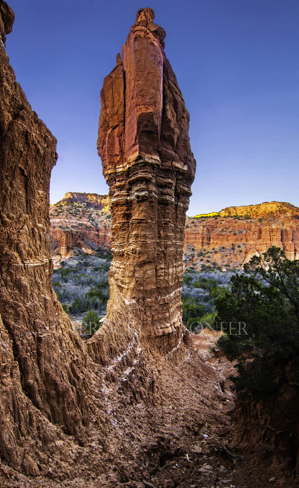
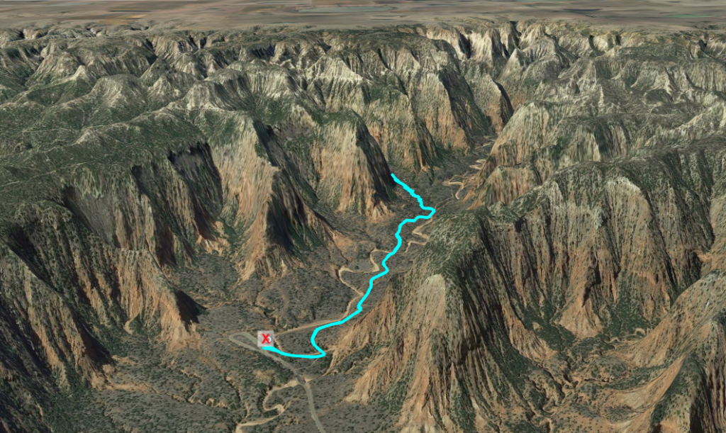
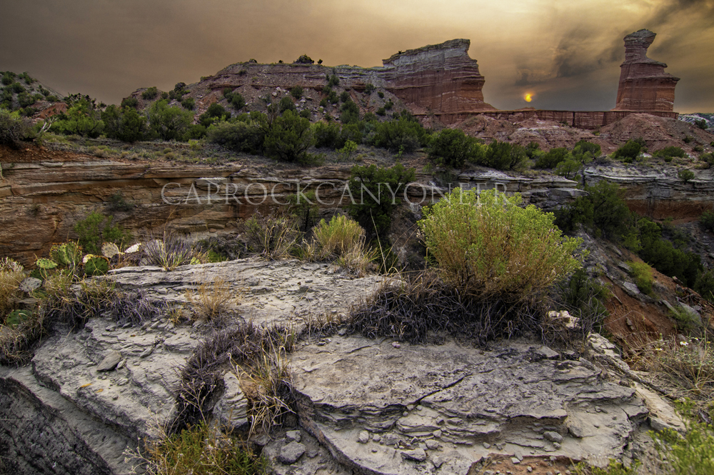
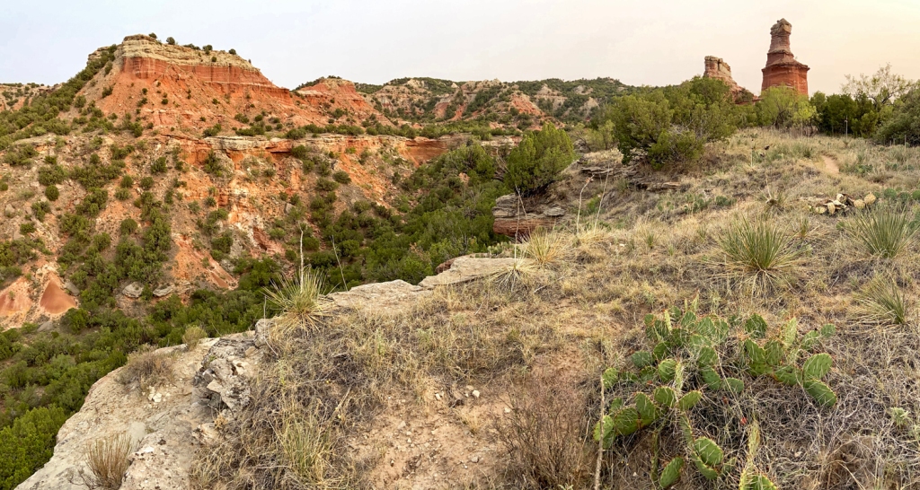
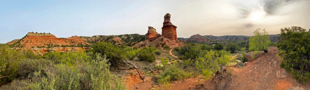
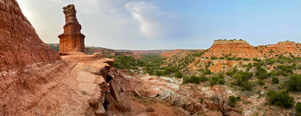
Upon reaching the canyonated escarpment and entering the park, I met long-time hiking partner, Barry, for the evening’s hike into the South Prong Canyon of the Little Red River. We began at a familiar spot along a familiar trail, the Upper Canyon Trail. I have always loved the view from the trailhead parking area as the “Cathedral of the Canyon” stands guard over the entrance to South Prong. It is a classic Caprock view.
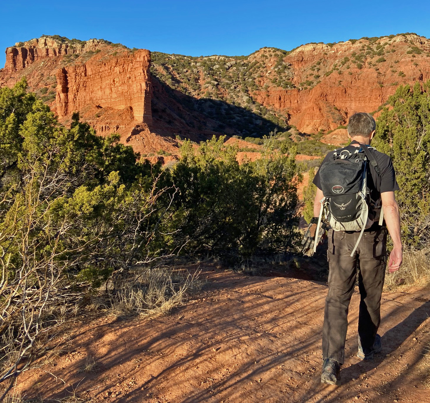
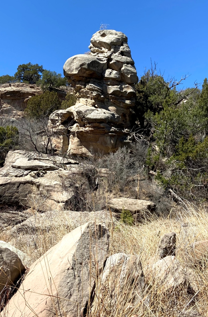
Our target was a little known landmark of this canyon, the South Prong Mitten. The Mitten is a massive sandstone pinnacle that stands south of the trail about a mile out from the trailhead. While the formation is large and prominent from certain vantage points, it is generally obscured from view from the casual hiker by thick brush. Like the Mittens at Monument Valley, the Mitten once had “finger” and “thumb” mini-spires that protruded from it, but the South Prong Mitten has proven to be very fragile in the years since I have been hiking in Caprock Canyons. Each time I photograph the formation, further erosion has left its mark.
As we first made our way up to the Mitten, the sun was still casting a light upon the time of the Quartermaster Sandstone. The scene made for a dramatic contrasted view of the warm glow against a cool cobalt sky and half moon.
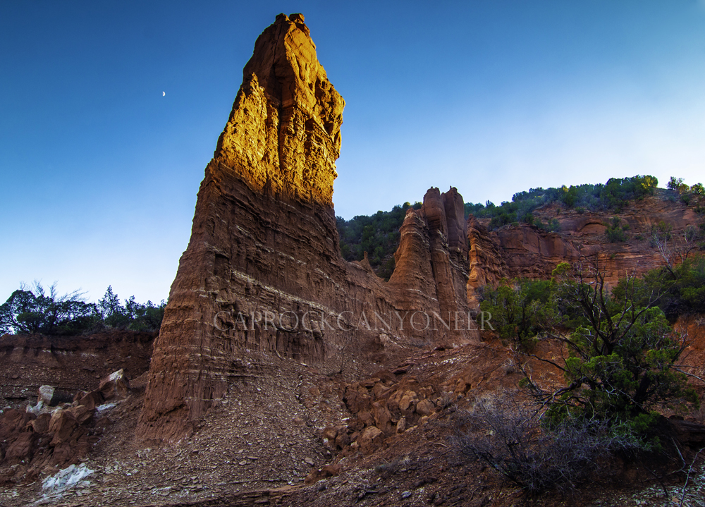
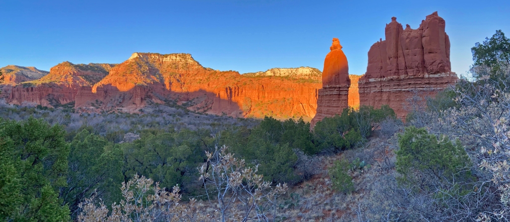
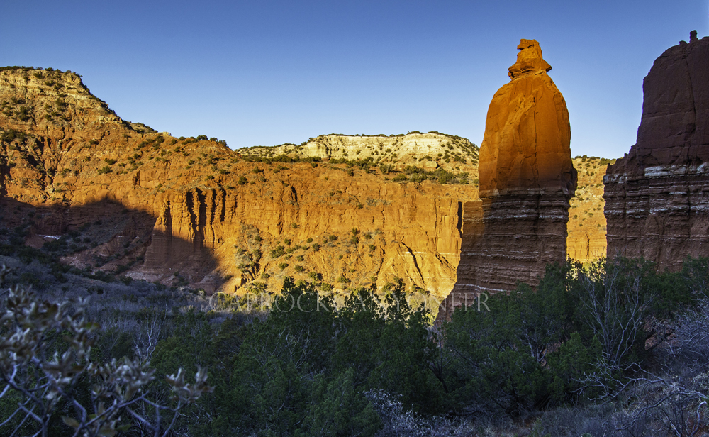
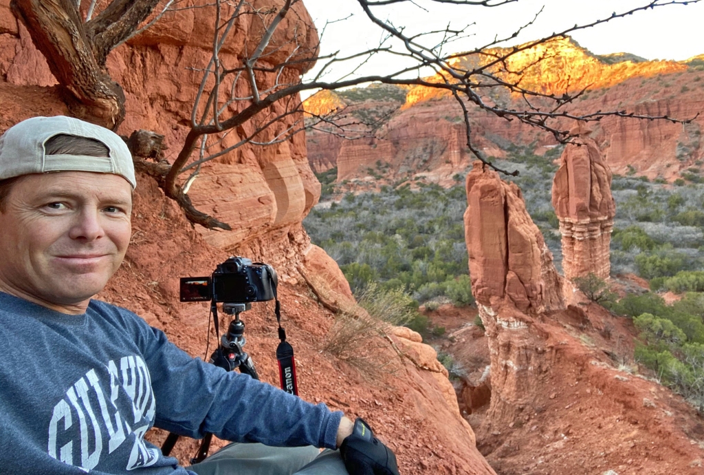
While we managed to capture a mere few minutes of glow in a low sun angle, unfortunately, we arrived about a half hour late to catch the Mitten in a full radiant glow. Although that was not the primary intend for our photoshoot, it was a little disappointing to know that was a photo opportunity just missed! Instead, we spent the final moments of sunlight casting alpenglow on the opposing north wall of the canyon scrambling to achieve unique shots from various angles. One of my favorite shots was taken from just above the base of the Mitten and shows the behemoth sandstone monolith towering above the valley floor, just as the last rays of sun kissed the north canyon rim.
Blue hour was spent hoping that the expected ‘Christmas star’ conjunction would be high enough to view above the south canyon wall from our position. The thicket surrounding the Mitten made repositioning difficult, but finally with some persistence and bushwhacking by headlight, we were able to see the apparition in its glory!
“When they saw the star, they rejoiced exceedingly with great joy.” Matthew 2:10
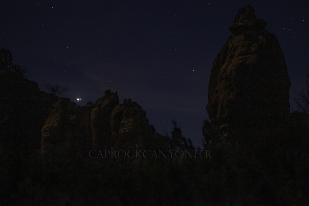
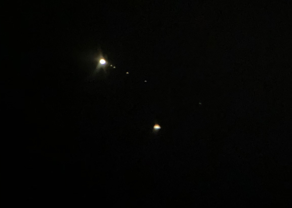
While this blog is neither an astronomical nor biblical theology forum, it seems prudent to review some quick facts and/or theories on the actual Star of Bethlehem in relation. Researchers say that a similar (but more widely spaced) conjunction occurred in 7 B.C. Others report that either a comet or supernova were likely reported as the star that marked Jesus’ birth in 5 A.D. Regardless, the visual brightness of the 2020 ‘Christmas star’ far exceeded our expectations as viewed from the backcountry of Caprock Canyons State Park. It was truly a highlight of this rather melancholy year to witness the spectacle from the place where I feel so much at home and so at peace- the canyons of the Llano Estacado.
‘The Altar’ of Palo Duro
There is a small but particularly hardy contingent of gentlemen that roam Palo Duro Canyon. I have not yet had the pleasure to make their acquaintance in person, but they sometimes refer to themselves online as “Dirtbags“. I will respectively call them “ironmen“. These men, all several years my elder, do not merely hike, bushwhack, backpack, or explore this canyon- they run it. That’s right! Imagine making all of the hikes I have documented on the pages of this blog, and more, while running! In fact, many of their social media posts suggest they run from one backcountry point of interest to the next, across difficult terrain that I would never attempt to connect on the best of my adventures. Many of these places have taken me years to visit, and they run from one to the next in a single day! So it is with these guys, who’s endurance and physical strength I admire.
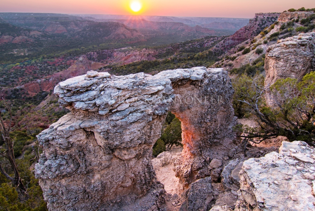
I also admire their online posts which occasionally show a small arch on the east rim of Palo Duro Canyon. A feature they coined ‘The Altar’. The Altar has been on my target list for years, but I admittedly suffer from an unhealthy obsession with slot canyons, in case you have not noticed! When planning a multiday hike with Rob Greebon (imagesfromtexas.com), however, we were looking for an interesting scene for sunset. Rob asked if there were any particularly good spots along the Rock Garden Trail, to which I instantly thought of the small arch on the rim that is, by my book, close enough. When the day of our planned hike arrived, Rob and I met at the trailhead. He asked me what I do to stay in shape, to which I responded that I run at least two 5Ks a week, but I could not help but think that even with that workout regiment, there is no way I am in as good of shape as the gentlemen that run to the sandstone arch we were about to visit!
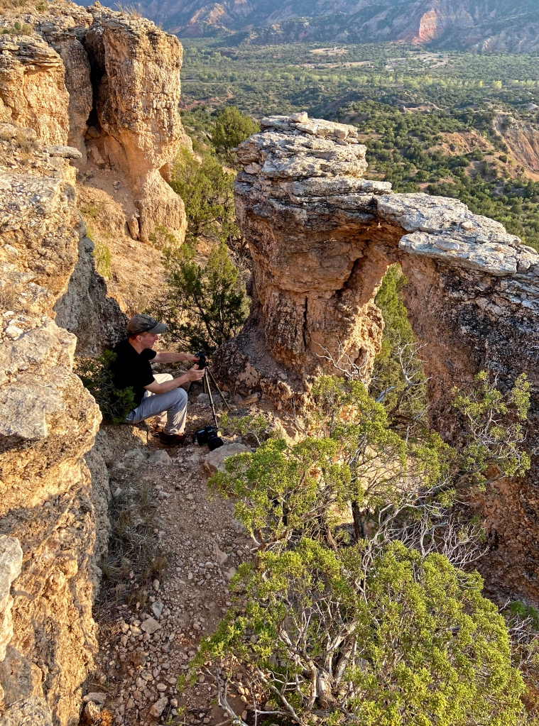
We started our trek up the Rock Garden Trail about two hours before sunset. It was an unusually hot day for mid October, with temperatures in the mid 90s. There was virtually no one else on the trail, with only one other vehicle at the trailhead parking lot. The Rock Garden Trail is quite scenic as it climbs the east wall of the canyon, weaving between and behind massive Trujillo boulders that litter the slope of the canyon wall. The trail itself is about two and a half miles as it ascends to the rim. We stayed true to the trail until we achieved a relative close approach to the rim shy of the trail’s terminus. There we began our offtrail scramble to the top of the Caprock. We crawled our way across loose crumbly ground and found access to the plains above without too much trouble, and then skirted the rim until we found the arch.
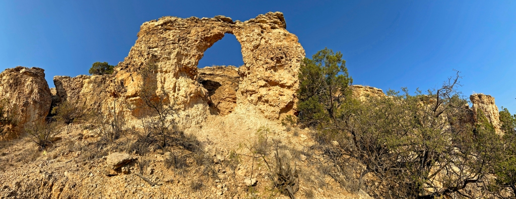
We arrived at The Altar about an hour prior to sunset. Instantly, we started setting up our compositions and strategizing how best to photograph the setting sun either through or over the arch. First, I ventured down the steep cliff below the arch to capture a panoramic view of The Altar from below. If timed properly, it appears a well crafted morning photograph could be captured here too. The space between the arch and the actual wall of the canyon rim was pretty restrictive, so Rob and I took turns preparing and actually framing images as the sun descended through the arched window toward the horizon. I have to admit, the view was much better than I had anticipated. Although not as prominent as what I had experienced during my sunset shoot at Lighthouse Peak last month, smoke from the massive wildfires in the West (this time in Colorado) was still casting an eerily dull warm glow. This gave both the sky and the arch a pinkish appearance just before the sun sank below the horizon.

Once the sun was down, the real challenge began. Rob and I began what would be a rushed descent of the canyon wall in an effort to beat darkness. We could see a trail below and slightly east of our position from The Altar. It appeared to be about 1,000 feet away, however, covering that distance was not as easy as it might sound. We scrambled and slid our way down a highly non-advisable path that put both of us on our rears at least a couple of times, all while twilight quickly faded. In fact, with the final 10 minutes or so of visually usable light, I was actually concerned we may not reach the trail by the time darkness would descend upon the canyon. Alas, we did! We finally intercepted the Upper Comanche Trail and followed it to its junction with the Rock Garden Trail. Feeling much better about what we had accomplished, the day’s work was not yet complete, as I had handedly tweaked my left knee in a fall up the slope and we were still more than a mile up the trail. To make the trek down even more interesting, we turned the corner of a switchback to see a long sinuous silhouette stretched across the trail in the heavily faded light. We both instantly froze, and in several seconds time, it became clear that it was not moving. We carefully approached and illuminated the dark figure sufficiently to conclude it was indeed, a stick! Realizing that if it was dark enough for us to confuse a downed tree branches for a snake, it was past time to break out our flashlights and headlamps. In otherwise absolute darkness we finally made it to our vehicles at the trailhead parking lot, just as the pain in my left knee was intensifying.
I can not know if we followed the same route that the ironmen runners of Palo Duro Canyon take to and from The Altar. I doubt it, as I believe they go much further. Regardless, now I know, they truly are in much better shape than I am! My hat’s off to the self-proclaimed Dirtbags and ‘The Altar’ of Palo Duro Canyon!
Slenderman and Wesley Slots
Recently, I had the opportunity to once again visit portions of lower South Cita Canyon. Readers of this blog may recall the June post following my initial hike to the Slenderman Slot of South Cita this past spring. That hike, and the photographs captured then, were reflected in a lengthy blog entry focused on the unsuspecting sense of adventure and discovery I found in the Llano wilderness on that trip. To truly understand the uniqueness of this canyon, please read that post.
This post will not be as elaborate. It turns out that the Slenderman Slot, while absolutely an impressive slot canyon that unexpectedly exists in the Texas Panhandle, does not undergo the same brilliant convulsion of light in mid-October that we experienced in late spring. That said, this canyon is still a worthy photographic subject any time. Not only that, but the adjacent area still offered chances to explore new (to me) sights – such as the Wesley Slot.
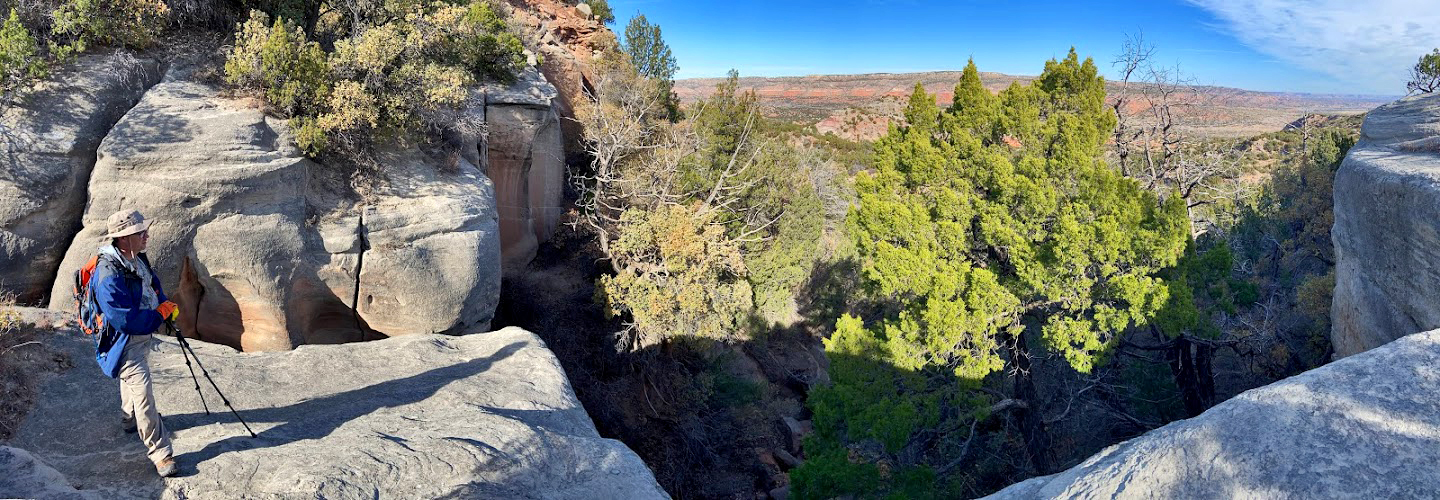
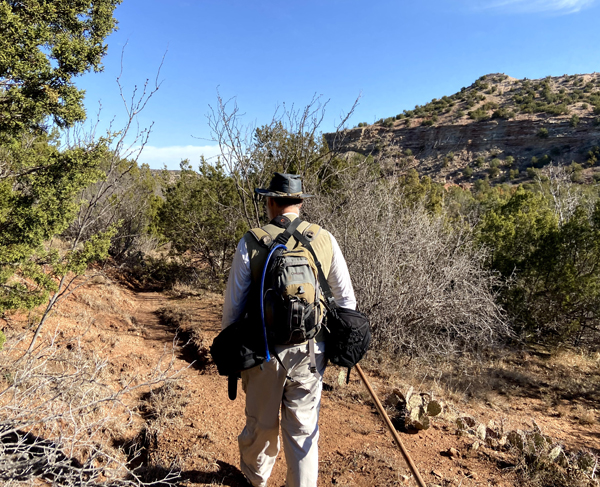
This hike was joined by our gracious guide, Bary (Nerdy Native) and photographer Rob Greebon (imagesfromtexas.com). Our hike began much like the last one to Slenderman, from a typical ranch setting near a muddy water tank! From there, cattle trails diverged in all directions. We followed a set of trails that headed toward the tip of Wesley Point. After about a mile of walking where cows walk, through mesquite thickets on the flat ground of Wesley Mesa, a sweeping view opened up to reveal South Cita Canyon. We then began descending into the canyon along an historic, and since disintegrated road, likely built by cowboys in the late 1800s to remove cedar trees. Lumbering in the Texas Panhandle, who would have thought it, right? Check out Bary’s excellent and recent blog post on the topic.
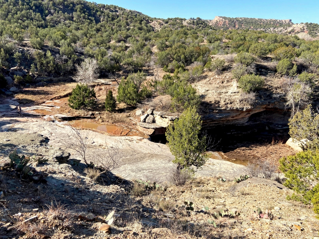
The dilapidated road eventually faded and we had to find another route, but it is a route Bary knows well. We exited into a dry arroyo that steeply enters the canyon from about 300 feet above. A cascade of moderate sized boulder, most some 3 to 4 feet in diameter, make the land barely passable in the form of a hidden natural staircase that can only be discerned once you start a leap down the faithful path. When the slope of our descent began to level out toward the middle rim of South Cita Canyon, we began to scramble through miniature slots that are only in their formative stages. Then, as we rounded a sharp curve, there was the mouth of Slenderman. From this vantage point, this remarkable feature only resembles a ragged ditch, but peering into its depths you begin to appreciate the artistry of time and water. As Bary set up a timelapse camera near the mouth of the canyon, Rob and I ventured to the other side of the parent box canyon. There we photographed a much shallower and less impressive slot, Wesley Slot.
Although Wesley Slot is a significantly less impressive canyon than Slenderman, I explained to Rob as we surveyed and photographed it, how this was actually the feature that first attracted us to this area of the Caprock. It is actually Wesley Slot that is much more prominent and impressive looking in Google Earth images, and it is what first caught our attention nearly a decade ago. It was only once our small group of hikers finally gained access to this part of the canyon earlier this year, that on the ground exploration revealed the true nature of the Slenderman Slot. After garnering years of attention and strategic planning for access, Wesley is now almost completely under appreciated. Rob and I, however, did take the opportunity to capture some photos of it and another nearby slot-like fissure which contained some very deep keeper holes. Both of which sported beautifully striated Trujillo sandstone.
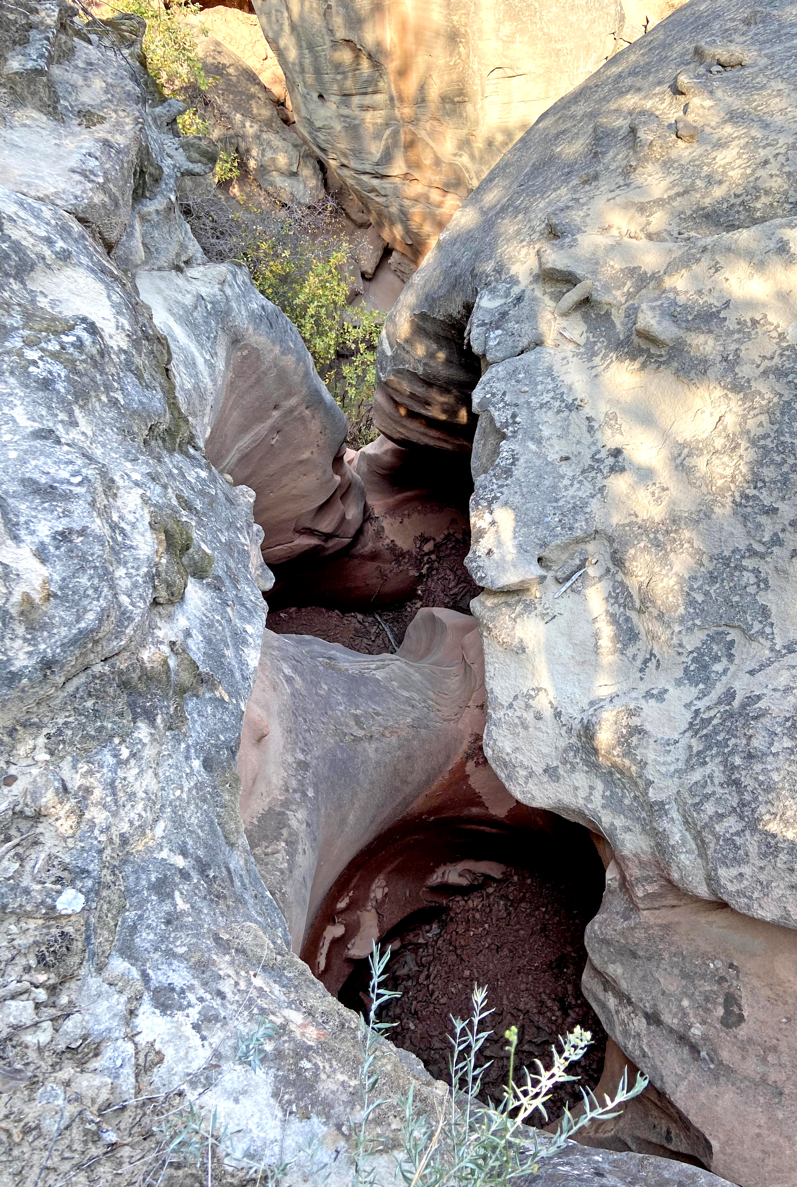
Faced with only steep drop offs from above, we finally bushwhacked our way around an adjacent point and down into a forested oasis at the head of the box canyon below. From there we were able to scramble through huge fallen Trujillo boulders to the mouth of the this area’s main attraction, Slenderman Slot. As we entered the cathedral entrance of the slot, we examined the cowboy rock art found in this most perfect shelter (remember Harvey?). We then took note of a bat roosting near the entrance to the narrowest part of the canyon. Then, we began to survey for light. Unfortunately, the light never really came, at least in the same fashion that it so gloriously filled this canyon the last time I was here. Back then, we witnessed and photographed remarkable light beams that shifted throughout the tight confines of this slot as the high sun angle passed over the rim of the slot. Yet, we were not to be denied. After about an hour and half of waiting, a burst of sun could be seen entering the upper chamber of the slot, and the room above exploded in warm colors of reflected light. Most unfortunately, the pit at the bottom of a 23 foot sluice that divides the lower portion of the canyon from the upper chamber was completely bogged in mud. Worse yet, the rope that Bary had previous rigged for ascending the sluice had been washed away. That made access to the upper reaches of the slot impossible. By laying on the ground, half in mud, under a narrow ledge-shaped opening, however, some brilliant slot images could still be rendered. I tried in desperation to make beams appear by tossing dust into the sunlight, but to no avail. Still, the images captured of this unique and remarkably structured canyon make a fine addition to my Llano slot canyon collection!
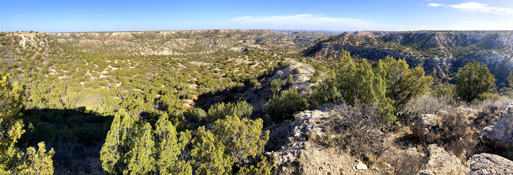
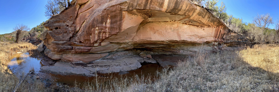
Missing From the Map – Red Canyon
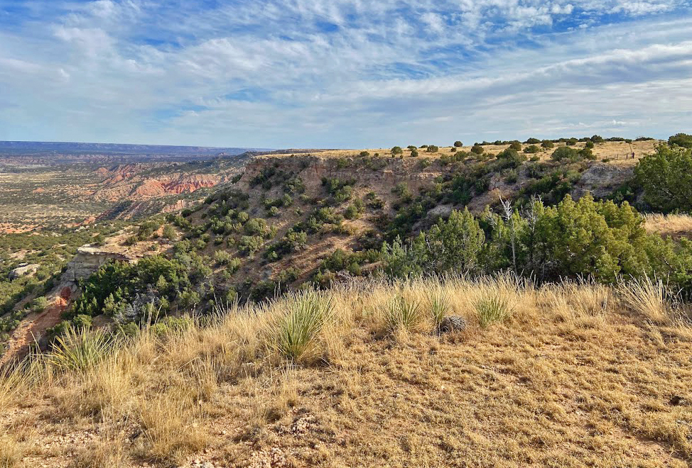
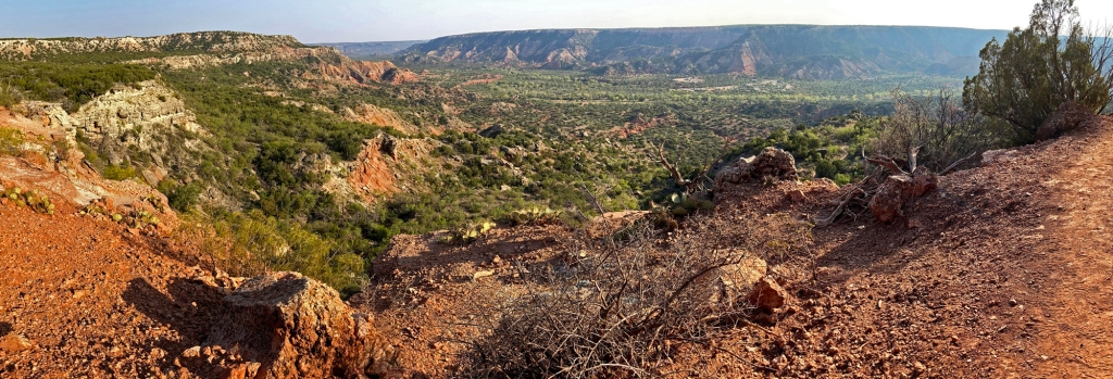
At some point during the past few years, and in reviewing the material posted on this blog, I have gradually came to the realization that there is a glaring omission. There is a place that I consider one the finest “secrets” of Palo Duro Canyon State Park, yet I have not posted a photograph of it on my Secrets of Palo Duro Canyon map. I have been to this gem of a site hidden in the backcountry, but I have always failed to properly capture its essence. You see, the scene at this special place is so big and vast, that it is almost impossible to render it justice. I do not mean figuratively, I mean literally with the limitations of most high quality cameras. But of course, nothing is impossible! In taking ‘B-roll’ images for this blog in recent years with my Iphone, I have come to realize that I can create wide sweeping panoramas of big scenes with it better than I can with my more conventional DSLR. Hence, a trip to appropriately capture the scene at the head of the remarkable Red Canyon was becoming high on my list. Such a photo opportunity would fill the missing gap in my “secrets” map. The question was when.
The dramatic box at the first head of the Palo Duro tributary known as Red Creek is a dramatically deep natural amphitheater that faces north. This makes favorable lighting hard to predict, and even harder to catch. The on-stage cast in this setting’s production includes a stand of healthy and proud ‘alpha’ cottonwoods (not a technical term, but my way to describe the huge trees that grow below the falls of dramatic box canyons) and at least two conifers. So, a quality photograph of this location should be timed so that the deciduous trees are not dormant and bare, but yet heat and summer overgrowth can be obstacles to reaching this off trail point. Thus, an early September morning seemed about perfect.
This day started with a courtesy view from the main lookout near the park entrance. As had been the problem for photography in recent weeks, obnoxious smoke from wildfires in the West was casting an unpleasing veil of brown and gray dullness in the skies above Palo Duro. Fortunately, a clearing line was visible to the northeast, and this gave me hope for capturing blue skies from the Red Canyon’s north aspect.
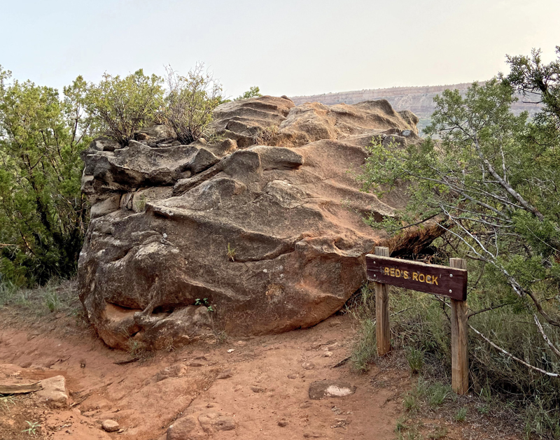
I began my trek at an access point along the Juniper/Cliffside Trail, and followed it north until it intersected Red Creek near “Red’s Rock”. I have no idea what the story of Red’s Rock is, or why it is deemed interesting enough to demark as a signed landmark, but here it is. The glaring face of Fortress Cliff was visible in the background along with the smoke-hazed sky, which I was hoping would clear before I reached the scenic grotto of Red Canyon.
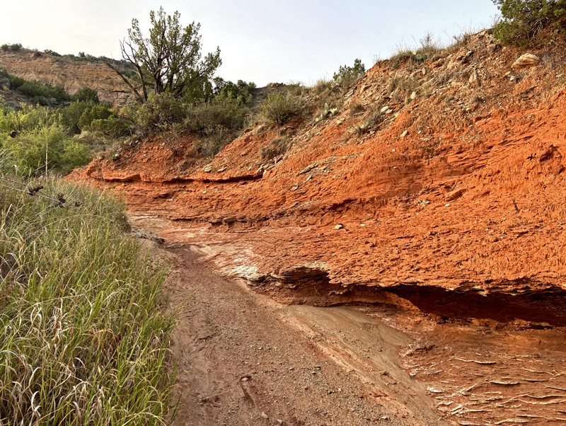
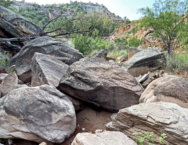
Typical of most Palo Duro side canyons, Red Canyon begins as an unassuming dry creek bed. Yes, the Quartermaster sandstone is indeed red in color here, but just as it is throughout the Llano canyons. There are a few interesting formations along the way, and eventually the obstacle-free sandy water drainage transforms into a mega boulder hop. In fact, I did not remember my last venture up this canyon being quite as strenuous as this one. Of course, that was seven years ago, and I believe I was half asleep after working a night shift in Amarillo! Either way, as I entered the elevation where the dry creek transforms into a true backcountry scramble with trickling water, I actually took two bad steps that could have ended my day.
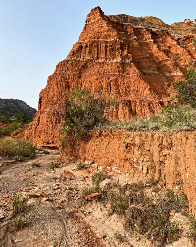
During one, my right boot slipped between two massive Trujillo boulders. I ended up knee-deep in red muddy water, but fortunately, my leg did not twist or snap! At several point along the way, the route became so rough that I began to question if I had followed the creek bed along a wrong bend. There are several side drainages that converge with the main stem, and the further along and more rugged it got, the less confident I was in my route finding, as my memory of this trek was a trouble-free short sub-mile hike. By watching the shape of the cliffs above, I knew I was on the right track. Finally, about a mile and a half in, I started to see some familiar terrain- I was only a few hundred yards away! Then, the view opened up as I walked into the natural amphitheater that is Red Canyon. The vertically dropping cliffs all around, the massive dry falls, and the sun just skimming the east rim promised to make a brilliant scene as the light shift and skies cleared.
As I scaled the crumbled and loose land slide that ascends to the massive grotto, the blue sky finally emerged and sunlight began to grace the tree tops and opposing canyon wall. The view was magnificent! As much as any view along the Caprock, this place looks like it was transported straight out of southern Utah- it just can’t be west Texas! Behold, the sweeping vista of Red Canyon!
For nearly two hours I sat there, nearly motionless, and just mesmerized by the view. It was perhaps the most quiet two hours I have ever spent in the canyon. The sound of buzzards flapping their wings while riding high upon the thermals above the opposite cliff was the only sound to be heard. As I sat and experienced this special place, my thoughts could not help but to be transformed into another time in this place. A time when Native Americans were the only humans to occupy this canyon. How is it even possible that there are not remnant pueblos here? This scene is exactly out of sacred places on the Colorado Plateau. The vast rock shelter here just seems too perfect for habitation. As I took in the view, my mind just imagined an ancient puebloan ruin merged with the landscape. Perhaps the way this canyon is constantly reshaped by landslides and erosion, it is just too dynamic for such structures to persist. I do not know, but I just can not believe that prehistoric generations of peoples, those that have left their mark in so many places around Palo Duro Canyon, had no presence here. It simply is not possible!
Lastly, I want to make a few overdue comments about the places I have documented throughout the years on my blog as “secret”. While I will not deliberately divulge coordinates or specific location information about most of them, they are not really secret at all. They are better described as off trail and potentially dangerous to access. I will not be responsible for anyone attempting to do so! Reaching them requires backcountry knowledge, route finding skills, and pure grit and determination. TPWD does not sanction off trail activity in the parks, and I am pretty sure resources available to respond to accidents are limited (although local rescuers should be commended for helping stranded and injured hikers in recent years). Should you choose to duplicate any of my hiking efforts to these places, you are solely on your own, and don’t ask me for help in finding them. That said, it is clear that those folks that love the Caprock of west Texas as much as I do, and who are sufficiently experienced in the great outdoors, do find these places. I just want to reiterate to all of my readers, that the goal of this blog is not, and has never been to brag about exclusive access to these secret treasures. I have no such access! Instead, it has only been through my own self-study and pure determination that I have photographed these places. I have a simple goal, to raise awareness of these wonderful places among those west Texans that are interested in nature and local history with the hope that more people will experience and appreciate the Llano wilderness in the future. That is precisely why I leave breadcrumb trails. Those that are willing and technically/physically able to find and enjoy these places will, on their own accord, do the research and planning required to do so safely. In the process, they will discover so much about this Plains landscape and its history, that they will strive to be responsible stewards for future generations. That is why I have spent nearly a decade writing this blog, so that you will know what is out there on the wild edges of the Llano Estacado, and so you may do your part to argue for its improved access and conservation too.
A Smokey Lighthouse Scene
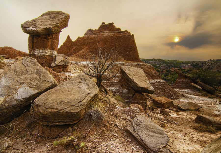
My annual pilgrimage to the Lighthouse came late this year. Ordinarily, I make the trek during the hottest part of summer, in either July or August. With all of the craziness and restrictions during this COVID-summer of 2020, however, my trips to canyon country were limited to a quick outing to photograph Comet NEOWISE in July. Of course, it was a pleasant relief when I finally did make the Lighthouse hike in mid September, with comfortable temperatures already descending onto the southern High Plains. Unfortunately, the cooler weather was not the only meteorological phenomenon occurring on the Plains. A thick veil of smoke emanating from wildfires on the West Coast greatly obscured the normally brilliant skies that the Texas Panhandle is so well known for during my visit. The grayish-red tinge tainted sky above the canyon cast an otherworldly scene onto the land, which made for an interesting photograph or two.
Otherwise, with the seemingly unnatural hues on the canyon and sky above, this adventure was far more of a ‘hike’ than a photographic opportunity. Less concerned about composing the perfect shot, I focused more on taking in this landscape that I adore. Wide sweeping IPhone panoramics were the order of the day more so than quality DSLR images.

Not all hikes can be recounted as thrilling and grand offtrail adventure, and this one certainly is not. Although it does not make the best story for an entertaining blog entry, I do enjoy these low key hikes to familiar places – especially this one. Hopefully you enjoy the scenery shared here too. Sometimes a relaxing hike can help you realize that Palo Duro Canyon (and other wildernesses), in all its beauty, has weathered many storms. The elements constantly reshape it, but it remains. Perhaps the storm we are all facing now will reshape us too. It undoubtedly has, and will continue to do so. Don’t take for granted the peace that can be found in places like this in troubled times.